
Topografische Karte Kat River
Interaktive Karte
Klicken Sie auf die Karte, um die Höhe anzuzeigen.
Über diese Karte
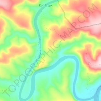
Name: Topografische Karte Kat River, Höhe, Relief.
Durchschnittliche Höhe: 326 m
Minimale Höhe: 193 m
Maximale Höhe: 522 m
Andere topografische Karten
Klicken Sie auf eine Karte, um ihre Topografie, ihre Höhe und ihr Relief anzuzeigen.
Hogsback
South Africa > Eastern Cape > Amathole District Municipality > Nkonkobe Local Municipality
Hogsback, Nkonkobe Local Municipality, Amathole District Municipality, Eastern Cape, 5721, South Africa
Durchschnittliche Höhe: 1.147 m
Alice
South Africa > Eastern Cape > Amathole District Municipality > Nkonkobe Local Municipality
Alice, Nkonkobe Local Municipality, Amathole District Municipality, Eastern Cape, South Africa
Durchschnittliche Höhe: 586 m
Fort Beaufort
South Africa > Eastern Cape > Amathole District Municipality > Nkonkobe Local Municipality > Fort Beaufort
Fort Beaufort, Nkonkobe Local Municipality, Amathole District Municipality, Eastern Cape, 5720, South Africa
Durchschnittliche Höhe: 482 m