
Topografische Karte Hitchin
Klicken Sie auf die Karte, um die Höhe anzuzeigen.
Über diese Karte
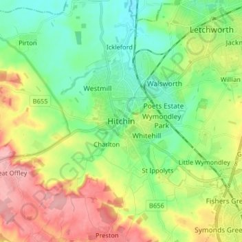
Name: Topografische Karte Hitchin, Höhe, Relief.
Durchschnittliche Höhe: 89 m
Minimale Höhe: 45 m
Maximale Höhe: 166 m
Andere topografische Karten
Klicken Sie auf eine Karte, um ihre Topografie, ihre Höhe und ihr Relief anzuzeigen.
Knebworth
United Kingdom > England > Hertfordshire > North Hertfordshire
Durchschnittliche Höhe: 103 m
Windmill Hill
United Kingdom > England > Hertfordshire > North Hertfordshire > Hitchin
Durchschnittliche Höhe: 74 m
St Ippolyts
United Kingdom > England > Hertfordshire > North Hertfordshire
Durchschnittliche Höhe: 103 m
Newnham
United Kingdom > England > Hertfordshire > North Hertfordshire > Baldock
Durchschnittliche Höhe: 69 m
Therfield
United Kingdom > England > Hertfordshire > North Hertfordshire
Durchschnittliche Höhe: 122 m
Knebworth Country Park
United Kingdom > England > Hertfordshire > North Hertfordshire > Knebworth
Durchschnittliche Höhe: 116 m
Great Ashby
United Kingdom > England > Hertfordshire > North Hertfordshire
Durchschnittliche Höhe: 134 m
King's Walden
United Kingdom > England > Hertfordshire > North Hertfordshire
Durchschnittliche Höhe: 134 m
St Paul's Walden
United Kingdom > England > Hertfordshire > North Hertfordshire
Durchschnittliche Höhe: 121 m
Ickleford
United Kingdom > England > Hertfordshire > North Hertfordshire > Hitchin
Durchschnittliche Höhe: 58 m
Ivel Springs Local Nature Reserve
United Kingdom > England > Hertfordshire > North Hertfordshire > Baldock
Durchschnittliche Höhe: 72 m
Long Pond
United Kingdom > England > Hertfordshire > North Hertfordshire > Offley > Offley Hoo
Durchschnittliche Höhe: 142 m
Knebworth Country Park
United Kingdom > England > Hertfordshire > North Hertfordshire > Knebworth
Durchschnittliche Höhe: 116 m