
Topografische Karte Weatherford
Interaktive Karte
Klicken Sie auf die Karte, um die Höhe anzuzeigen.
Über diese Karte
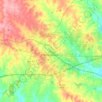
Name: Topografische Karte Weatherford, Höhe, Relief.
Ort: Weatherford, Parker County, Texas, 76086, United States (32.71167 -97.84999 32.81808 -97.66008)
Durchschnittliche Höhe: 326 m
Minimale Höhe: 266 m
Maximale Höhe: 399 m
Andere topografische Karten
Klicken Sie auf eine Karte, um ihre Topografie, ihre Höhe und ihr Relief anzuzeigen.
Dennis
United States > Texas > Parker County
Dennis, Parker County, Texas, United States
Durchschnittliche Höhe: 233 m
Agnes
United States > Texas > Parker County
Agnes, Parker County, Texas, 76482, United States
Durchschnittliche Höhe: 351 m
Aledo
United States > Texas > Parker County
Aledo, Parker County, Texas, United States
Durchschnittliche Höhe: 271 m
Garner
United States > Texas > Parker County
Garner, Parker County, Texas, United States
Durchschnittliche Höhe: 296 m
Lake Weatherford
United States > Texas > Parker County > Weatherford
Lake Weatherford, Weatherford, Parker County, Texas, United States
Durchschnittliche Höhe: 289 m
Reno
United States > Texas > Parker County > Reno > Reno
Reno, Parker County, Texas, United States
Durchschnittliche Höhe: 226 m