
Spenden
Rüste dich für dein nächstes Abenteuer:
Als Amazon-Partner verdient diese Website an qualifizierten Käufen, ohne zusätzliche Kosten für Sie.
Topografische Karte Port Charlotte
Klicken Sie auf die Karte, um die Höhe anzuzeigen.
Spenden
Rüste dich für dein nächstes Abenteuer:
Als Amazon-Partner verdient diese Website an qualifizierten Käufen, ohne zusätzliche Kosten für Sie.
Über diese Karte
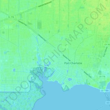
Name: Topografische Karte Port Charlotte, Höhe, Relief.
Ort: Port Charlotte, Charlotte County, Florida, United States (26.94693 -82.15629 27.01802 -82.05760)
Durchschnittliche Höhe: 4 m
Minimale Höhe: -2 m
Maximale Höhe: 10 m
Spenden
Rüste dich für dein nächstes Abenteuer:
Als Amazon-Partner verdient diese Website an qualifizierten Käufen, ohne zusätzliche Kosten für Sie.
Andere topografische Karten
Klicken Sie auf eine Karte, um ihre Topografie, ihre Höhe und ihr Relief anzuzeigen.
Punta Gorda
United States > Florida > Charlotte County
Punta Gorda features a predominantly flat topography characterized by its low elevation, averaging around 7 to 10 feet above sea level. The terrain is primarily made up of coastal plains and wetlands, interspersed with small hills such as those found in South Punta Gorda Heights, which can reach elevations of…
Durchschnittliche Höhe: 3 m
Tee and Green Estates
United States > Florida > Charlotte County > Cleveland
Durchschnittliche Höhe: 4 m
Spenden
Rüste dich für dein nächstes Abenteuer:
Als Amazon-Partner verdient diese Website an qualifizierten Käufen, ohne zusätzliche Kosten für Sie.
Spenden
Rüste dich für dein nächstes Abenteuer:
Als Amazon-Partner verdient diese Website an qualifizierten Käufen, ohne zusätzliche Kosten für Sie.
Punta Gorda Isles
United States > Florida > Charlotte County > Punta Gorda > Punta Gorda Isles
Durchschnittliche Höhe: 2 m
Spenden
Rüste dich für dein nächstes Abenteuer:
Als Amazon-Partner verdient diese Website an qualifizierten Käufen, ohne zusätzliche Kosten für Sie.
Spenden
Rüste dich für dein nächstes Abenteuer:
Als Amazon-Partner verdient diese Website an qualifizierten Käufen, ohne zusätzliche Kosten für Sie.
South Punta Gorda Heights
United States > Florida > Charlotte County > Punta Gorda
Durchschnittliche Höhe: 8 m
Spenden
Rüste dich für dein nächstes Abenteuer:
Als Amazon-Partner verdient diese Website an qualifizierten Käufen, ohne zusätzliche Kosten für Sie.
Tee and Green Estates
United States > Florida > Charlotte County > Cleveland
Durchschnittliche Höhe: 4 m
Spenden
Rüste dich für dein nächstes Abenteuer:
Als Amazon-Partner verdient diese Website an qualifizierten Käufen, ohne zusätzliche Kosten für Sie.
Spenden
Rüste dich für dein nächstes Abenteuer:
Als Amazon-Partner verdient diese Website an qualifizierten Käufen, ohne zusätzliche Kosten für Sie.
Placida
United States > Florida > Charlotte County
Placida is located at 26°49′55″N 82°15′54″W / 26.83194°N 82.265°W / 26.83194; -82.265Coordinates: 26°49′55″N 82°15′54″W / 26.83194°N 82.265°W / 26.83194; -82.265 (26.83194, -82.265). Placida has an elevation of 3 feet.
Durchschnittliche Höhe: 1 m
Spenden
Rüste dich für dein nächstes Abenteuer:
Als Amazon-Partner verdient diese Website an qualifizierten Käufen, ohne zusätzliche Kosten für Sie.