
Topografische Karte Cártama
Interaktive Karte
Klicken Sie auf die Karte, um die Höhe anzuzeigen.
Über diese Karte
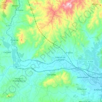
Name: Topografische Karte Cártama, Höhe, Relief.
Ort: Cártama, Valle del Guadalhorce, Malaga, Andalusia, Spain (36.68762 -4.77897 36.80976 -4.56898)
Durchschnittliche Höhe: 173 m
Minimale Höhe: 9 m
Maximale Höhe: 784 m
The original town, Cártama Pueblo, stretches across the steep side of the Hill of the Virgin (240 m over the sea level). Its buildings and roads follow the contours of the hill, and reflect the varied topography of the area.
Andere topografische Karten
Klicken Sie auf eine Karte, um ihre Topografie, ihre Höhe und ihr Relief anzuzeigen.
Almogía
Spain > Andalusia > Valle del Guadalhorce
Almogía, Valle del Guadalhorce, Malaga, Andalusia, 29150, Spain
Durchschnittliche Höhe: 387 m