
Topografische Karte Hometown
Interaktive Karte
Klicken Sie auf die Karte, um die Höhe anzuzeigen.
Über diese Karte
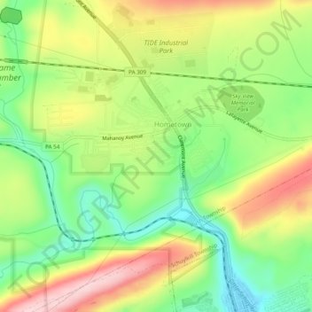
Name: Topografische Karte Hometown, Höhe, Relief.
Durchschnittliche Höhe: 352 m
Minimale Höhe: 249 m
Maximale Höhe: 481 m
According to the United States Census Bureau, the CDP has a total area of 2.0 square miles (5.2 km2), all land. Hometown is located 2 miles (3.2 km) north of Tamaqua and 10 miles (16 km) south of Hazleton at the intersections of Route 54 and 309. Hometown's elevation is 1,129 feet (344 m) above sea level. It uses the Tamaqua zip code of 18252.