
Topografische Karte Grays Peak
Interaktive Karte
Klicken Sie auf die Karte, um die Höhe anzuzeigen.
Über diese Karte
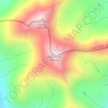
Name: Topografische Karte Grays Peak, Höhe, Relief.
Ort: Grays Peak, Clear Creek County, Colorado, United States (39.63383 -105.81756 39.63393 -105.81746)
Durchschnittliche Höhe: 3.914 m
Minimale Höhe: 3.497 m
Maximale Höhe: 4.341 m
Grays Peak is one of 53 fourteeners (mountains of over 14,000 feet (4,300 m) in elevation) in Colorado. Botanist Charles C. Parry made the first recorded ascent of the summit in 1861 and named the peak in honor of his botanist colleague Asa Gray. Gray did not see (and climb) the peak until 1872, eleven years later. Grays Peak is commonly mentioned in conjunction with adjacent Torreys Peak.
Andere topografische Karten
Klicken Sie auf eine Karte, um ihre Topografie, ihre Höhe und ihr Relief anzuzeigen.
Blue Valley
United States > Colorado > Clear Creek County
Blue Valley, Clear Creek County, Colorado, 80254, United States
Durchschnittliche Höhe: 2.966 m
Mount Blue Sky
United States > Colorado > Clear Creek County
Mount Blue Sky, Clear Creek County, Colorado, United States
Durchschnittliche Höhe: 4.006 m
Berthoud Falls
United States > Colorado > Clear Creek County
Berthoud Falls, Clear Creek County, Colorado, United States
Durchschnittliche Höhe: 3.357 m
Breckinridge Peak
United States > Colorado > Clear Creek County
Breckinridge Peak, Clear Creek County, Colorado, United States
Durchschnittliche Höhe: 3.637 m
Loveland Pass
United States > Colorado > Clear Creek County
Loveland Pass, Clear Creek County, Colorado, United States
Durchschnittliche Höhe: 3.639 m
Georgetown
United States > Colorado > Clear Creek County
Georgetown, Clear Creek County, Colorado, 80444, United States
Durchschnittliche Höhe: 2.974 m
St. Mary's
United States > Colorado > Clear Creek County
St. Mary's, Clear Creek County, Colorado, United States
Durchschnittliche Höhe: 3.281 m
Idaho Springs
United States > Colorado > Clear Creek County > Idaho Springs > Idaho Springs
Idaho Springs, Clear Creek County, Colorado, 80452, United States
Durchschnittliche Höhe: 2.624 m
Lawson
United States > Colorado > Clear Creek County > Lawson
Lawson, Clear Creek County, Colorado, 80436, United States
Durchschnittliche Höhe: 2.766 m
Idaho Springs
United States > Colorado > Clear Creek County
Idaho Springs, Clear Creek County, Colorado, 80452, United States
Durchschnittliche Höhe: 2.663 m