
Topografische Karte Haxey
Klicken Sie auf die Karte, um die Höhe anzuzeigen.
Haxey
The civil parish includes the town of Haxey and the village of Westwoodside, and the hamlets of Haxey Carr, High Burnham (the highest elevation of the Isle of Axholme), Low Burnham, East Lound, Graizelound and Upperthorpe which is conjoined to Westwoodside.
Über diese Karte
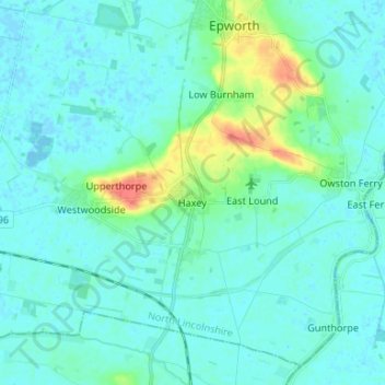
Name: Topografische Karte Haxey, Höhe, Relief.
Durchschnittliche Höhe: 7 m
Minimale Höhe: -4 m
Maximale Höhe: 42 m
Andere topografische Karten
Klicken Sie auf eine Karte, um ihre Topografie, ihre Höhe und ihr Relief anzuzeigen.
North Garth
United Kingdom > England > North Lincolnshire > North Killingholme
Durchschnittliche Höhe: 9 m
Thealby
United Kingdom > England > North Lincolnshire > Burton upon Stather
Durchschnittliche Höhe: 41 m
Coskills
United Kingdom > England > North Lincolnshire > Barnetby le Wold
Durchschnittliche Höhe: 35 m