
Topografische Karte Dolly Sods Wilderness
Interaktive Karte
Klicken Sie auf die Karte, um die Höhe anzuzeigen.
Über diese Karte
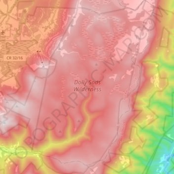
Name: Topografische Karte Dolly Sods Wilderness, Höhe, Relief.
Durchschnittliche Höhe: 1.042 m
Minimale Höhe: 347 m
Maximale Höhe: 1.351 m
Dolly Sods is a rocky, high-altitude plateau with sweeping vistas and lifeforms normally found much farther north in Canada. To the north, the distinctive landscape of "the Sods" is characterized by stunted ("flagged") trees, wind-carved boulders, heath barrens, grassy meadows created in the last century by logging and fires, and sphagnum bogs that are much older. To the south, a dense cove forest occupies the branched canyon excavated by the North Fork of Red Creek.
Andere topografische Karten
Klicken Sie auf eine Karte, um ihre Topografie, ihre Höhe und ihr Relief anzuzeigen.
Otter Creek
United States > West Virginia > Tucker County
Otter Creek, Tucker County, West Virginia, United States
Durchschnittliche Höhe: 914 m
Canaan Valley Resort State Park
United States > West Virginia > Tucker County
Canaan Valley Resort State Park, Pointy Knob Road, Tucker County, West Virginia, 26263, United States
Durchschnittliche Höhe: 1.033 m
Davis
United States > West Virginia > Tucker County
Davis, Tucker County, West Virginia, United States
Durchschnittliche Höhe: 955 m
Thomas
United States > West Virginia > Tucker County
Thomas, Tucker County, West Virginia, 26292, United States
Durchschnittliche Höhe: 947 m
Fairfax Stone State Park
United States > West Virginia > Tucker County
Fairfax Stone State Park, Tucker County, West Virginia, United States
Durchschnittliche Höhe: 913 m
Location
United States > West Virginia > Tucker County
Location, Tucker County, West Virginia, United States
Durchschnittliche Höhe: 722 m
Parsons
United States > West Virginia > Tucker County
Parsons, Tucker County, West Virginia, 26287, United States
Durchschnittliche Höhe: 556 m