
Spenden
Rüste dich für dein nächstes Abenteuer:
Als Amazon-Partner verdient diese Website an qualifizierten Käufen, ohne zusätzliche Kosten für Sie.
Topografische Karte Fairfax
Klicken Sie auf die Karte, um die Höhe anzuzeigen.
Spenden
Rüste dich für dein nächstes Abenteuer:
Als Amazon-Partner verdient diese Website an qualifizierten Käufen, ohne zusätzliche Kosten für Sie.
Fairfax
Fairfax is an incorporated town in Marin County, California, United States. Fairfax is located 3.25 miles (5.2 km) west-northwest of San Rafael, at an elevation of 115 feet (35 m). The population was 7,605 at the 2020 census.
Spenden
Rüste dich für dein nächstes Abenteuer:
Als Amazon-Partner verdient diese Website an qualifizierten Käufen, ohne zusätzliche Kosten für Sie.
Über diese Karte
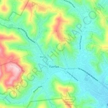
Name: Topografische Karte Fairfax, Höhe, Relief.
Ort: Fairfax, Marin County, California, 94930, United States (37.97308 -122.61994 38.00977 -122.57936)
Durchschnittliche Höhe: 97 m
Minimale Höhe: 14 m
Maximale Höhe: 259 m
Spenden
Rüste dich für dein nächstes Abenteuer:
Als Amazon-Partner verdient diese Website an qualifizierten Käufen, ohne zusätzliche Kosten für Sie.
Andere topografische Karten
Klicken Sie auf eine Karte, um ihre Topografie, ihre Höhe und ihr Relief anzuzeigen.
Woodacre
United States > California > Marin County
The community is located at 38°00′46″N 122°38′43″W / 38.01278°N 122.64528°W / 38.01278; -122.64528 in the eastern half of the San Geronimo Valley of central Marin County. San Geronimo and Lagunitas-Forest Knolls are to its west. Woodacre is located 8 miles (13 km) south-southwest of…
Durchschnittliche Höhe: 246 m
Spenden
Rüste dich für dein nächstes Abenteuer:
Als Amazon-Partner verdient diese Website an qualifizierten Käufen, ohne zusätzliche Kosten für Sie.
Bolinas
United States > California > Marin County
Bolinas sits at an elevation of 36 feet (11 m) above sea level. It is bound on the northeast by Bolinas Lagoon and Kent Island, on the south by Bolinas Bay and Duxbury Point, on the southwest by the Pacific Ocean, and on the northwest by Point Reyes National Seashore. According to the United States Census…
Durchschnittliche Höhe: 28 m
Spenden
Rüste dich für dein nächstes Abenteuer:
Als Amazon-Partner verdient diese Website an qualifizierten Käufen, ohne zusätzliche Kosten für Sie.
Spenden
Rüste dich für dein nächstes Abenteuer:
Als Amazon-Partner verdient diese Website an qualifizierten Käufen, ohne zusätzliche Kosten für Sie.
Stinson Beach
United States > California > Marin County
Stinson Beach is an unincorporated community and census-designated place (CDP) in Marin County, California, on the west coast of the United States. Stinson Beach is located east-southeast of Bolinas, right across the channel that terminates the bay mouth bar of the Bolinas Lagoon. at an elevation of 26 feet (8…
Durchschnittliche Höhe: 155 m
Spenden
Rüste dich für dein nächstes Abenteuer:
Als Amazon-Partner verdient diese Website an qualifizierten Käufen, ohne zusätzliche Kosten für Sie.
Los Ranchitos Park
United States > California > Marin County > San Rafael > Cerro
Durchschnittliche Höhe: 50 m
Spenden
Rüste dich für dein nächstes Abenteuer:
Als Amazon-Partner verdient diese Website an qualifizierten Käufen, ohne zusätzliche Kosten für Sie.
San Geronimo
United States > California > Marin County
San Geronimo (Spanish: San Gerónimo, meaning "St. Jerome") is a census-designated place (CDP) located in the San Geronimo Valley in Marin County, California in the United States. San Geronimo is bordered by Lagunitas-Forest Knolls to its west and Woodacre to its east. It is 8 miles (13 km) southwest of…
Durchschnittliche Höhe: 234 m
Point Reyes
United States > California > Marin County
Point Reyes is bounded to the east by the San Andreas Fault, which runs directly under Tomales Bay, and is structurally dominated by the Point Reyes Syncline. The Point Reyes Peninsula is on the Pacific Plate, while the rest of Marin County land is on the North American Plate. The peninsula is a member of the…
Durchschnittliche Höhe: 10 m
Spenden
Rüste dich für dein nächstes Abenteuer:
Als Amazon-Partner verdient diese Website an qualifizierten Käufen, ohne zusätzliche Kosten für Sie.
Spenden
Rüste dich für dein nächstes Abenteuer:
Als Amazon-Partner verdient diese Website an qualifizierten Käufen, ohne zusätzliche Kosten für Sie.
Spenden
Rüste dich für dein nächstes Abenteuer:
Als Amazon-Partner verdient diese Website an qualifizierten Käufen, ohne zusätzliche Kosten für Sie.
Baltimore Park
United States > California > Marin County > Larkspur > Baltimore Park
Durchschnittliche Höhe: 58 m