
Topografische Karte Bellefontaine
Interaktive Karte
Klicken Sie auf die Karte, um die Höhe anzuzeigen.
Über diese Karte
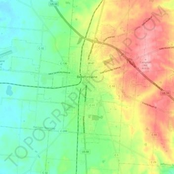
Name: Topografische Karte Bellefontaine, Höhe, Relief.
Durchschnittliche Höhe: 384 m
Minimale Höhe: 326 m
Maximale Höhe: 471 m
The city of Bellefontaine is at the convergence of the humid subtropical (Köppen Cfa) and humid continental (Köppen Dfa) climate zones according to the Köppen climate map. The region is characterized by four distinct seasons. Winters are cool to cold with mild periods, and summers are generally hot and muggy, with significant precipitation year-round. The city is too far south to experience lake effect snow from the Great Lakes region, however it does experience more snow than surrounding areas due to the city's elevation. Traditionally, Bellefontaine's elevation excludes it from tornadoes and floods that affect the majority of the Miami Valley.
Andere topografische Karten
Klicken Sie auf eine Karte, um ihre Topografie, ihre Höhe und ihr Relief anzuzeigen.
Big Springs
United States > Ohio > Logan County
Big Springs, Rushcreek Township, Logan County, Ohio, 43347, United States
Durchschnittliche Höhe: 344 m
Belle Center
United States > Ohio > Logan County
Belle Center, Richland Township, Logan County, Ohio, United States
Durchschnittliche Höhe: 320 m
Lewistown
United States > Ohio > Logan County
Lewistown, Washington Township, Logan County, Ohio, 43333, United States
Durchschnittliche Höhe: 311 m
West Mansfield
United States > Ohio > Logan County
West Mansfield, Bokescreek Township, Logan County, Ohio, United States
Durchschnittliche Höhe: 333 m
Zanesfield
United States > Ohio > Logan County
Zanesfield, Jefferson Township, Logan County, Ohio, United States
Durchschnittliche Höhe: 379 m
Rushsylvania
United States > Ohio > Logan County
Rushsylvania, Rushcreek Township, Logan County, Ohio, United States
Durchschnittliche Höhe: 378 m
New Jerusalem
United States > Ohio > Logan County
New Jerusalem, Jefferson Township, Logan County, Ohio, United States
Durchschnittliche Höhe: 413 m
Crystal Beach
United States > Ohio > Logan County
Crystal Beach, Washington Township, Logan County, Ohio, United States
Durchschnittliche Höhe: 305 m
Russells Point
United States > Ohio > Logan County
Russells Point, Washington Township, Logan County, Ohio, United States
Durchschnittliche Höhe: 303 m
Lakeview
United States > Ohio > Logan County
Lakeview, Stokes Township, Logan County, Ohio, United States
Durchschnittliche Höhe: 303 m
Valley Hi
United States > Ohio > Logan County
Valley Hi, Monroe Township, Logan County, Ohio, United States
Durchschnittliche Höhe: 381 m
Indian Lake
United States > Ohio > Logan County > Russells Point
Indian Lake, Russells Point, Stokes Township, Logan County, Ohio, United States
Durchschnittliche Höhe: 306 m
Huntsville
United States > Ohio > Logan County
Huntsville, McArthur Township, Logan County, Ohio, United States
Durchschnittliche Höhe: 332 m
Wolf Island
United States > Ohio > Logan County
Wolf Island, Stokes Township, Logan County, Ohio, United States
Durchschnittliche Höhe: 303 m
Zane Township
United States > Ohio > Logan County
Zane Township, Logan County, Ohio, United States
Durchschnittliche Höhe: 363 m
Logansville
United States > Ohio > Logan County > Logansville
Logansville, Pleasant Township, Logan County, Ohio, 43318:45340, United States
Durchschnittliche Höhe: 313 m
Shawnee Island
United States > Ohio > Logan County
Shawnee Island, Stokes Township, Logan County, Ohio, United States
Durchschnittliche Höhe: 305 m
Cherokee
United States > Ohio > Logan County
Cherokee, McArthur Township, Logan County, Ohio, 43324, United States
Durchschnittliche Höhe: 344 m