
Topografische Karte Launceston
Interaktive Karte
Klicken Sie auf die Karte, um die Höhe anzuzeigen.
Über diese Karte
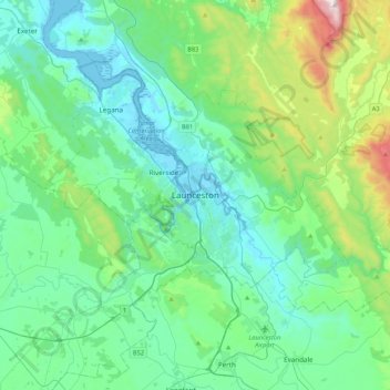
Name: Topografische Karte Launceston, Höhe, Relief.
Ort: Launceston, Tasmania, 7250, Australia (-41.59408 146.97735 -41.27408 147.29735)
Durchschnittliche Höhe: 218 m
Minimale Höhe: -3 m
Maximale Höhe: 1.171 m
Launceston is at 41°26′31″S 147°8′42″E / 41.44194°S 147.14500°E / -41.44194; 147.14500 in the Tamar Valley, Northern Tasmania. The valley was formed by volcanic and glacial forces over 10 million years ago. The city is about 45 kilometres (28 mi) south of the Bass Strait, with its closest neighbour-city being Devonport, about 99 kilometres (62 mi) to the north west. Launceston combines steep (originally heavily wooded) ridges and low-lying areas (originally wetlands – with parts of the suburbs of Inveresk and Invermay below high-tide level). As a result, areas of Launceston are subject to landslip problems, while others are liable to poor drainage and periodic flooding. The topography of the area is not conducive to easy dispersion of airborne pollution, due to the phenomenon of thermal inversion.
Andere topografische Karten
Klicken Sie auf eine Karte, um ihre Topografie, ihre Höhe und ihr Relief anzuzeigen.
Kings Meadows
Australia > Tasmania > Launceston
Kings Meadows, Launceston, City of Launceston, Tasmania, 7249, Australia
Durchschnittliche Höhe: 89 m
Legana
Australia > Tasmania > Launceston > Legana
Legana, Launceston, West Tamar, Tasmania, Australia
Durchschnittliche Höhe: 82 m
Riverside
Australia > Tasmania > Launceston
Riverside, Launceston, West Tamar, Tasmania, Australia
Durchschnittliche Höhe: 111 m
Hadspen
Australia > Tasmania > Launceston
Hadspen, Launceston, Meander Valley, Tasmania, 7290, Australia
Durchschnittliche Höhe: 171 m