
Topografische Karte Taman Seruni Indah
Interaktive Karte
Klicken Sie auf die Karte, um die Höhe anzuzeigen.
Über diese Karte
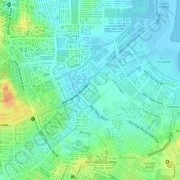
Name: Topografische Karte Taman Seruni Indah, Höhe, Relief.
Ort: Taman Seruni Indah, Batam City, Riau Islands, 29456, Indonesia (1.11992 104.02978 1.13992 104.04978)
Durchschnittliche Höhe: 16 m
Minimale Höhe: -2 m
Maximale Höhe: 52 m
Andere topografische Karten
Klicken Sie auf eine Karte, um ihre Topografie, ihre Höhe und ihr Relief anzuzeigen.
Lubuk Baja Kota
Indonesia > Riau Islands > Batam City
Lubuk Baja Kota, Batam City, Riau Islands, Sumatra, 29443, Indonesia
Durchschnittliche Höhe: 18 m
Teluk Tering
Indonesia > Riau Islands > Batam City > Teluk Tering
Teluk Tering, Batam City, Riau Islands, 24961, Indonesia
Durchschnittliche Höhe: 13 m
Keban
Indonesia > Riau Islands > Batam City
Keban, Batam City, Riau Islands, Indonesia
Durchschnittliche Höhe: 4 m