
Topografische Karte Dell Rapids Township
Interaktive Karte
Klicken Sie auf die Karte, um die Höhe anzuzeigen.
Über diese Karte
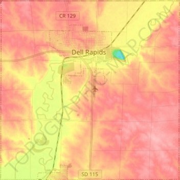
Name: Topografische Karte Dell Rapids Township, Höhe, Relief.
Durchschnittliche Höhe: 470 m
Minimale Höhe: 400 m
Maximale Höhe: 502 m
Andere topografische Karten
Klicken Sie auf eine Karte, um ihre Topografie, ihre Höhe und ihr Relief anzuzeigen.
Sioux Falls
United States > South Dakota > Minnehaha County
Sioux Falls, Sioux Falls Township, Minnehaha County, South Dakota, United States
Durchschnittliche Höhe: 445 m
Brandon
United States > South Dakota > Minnehaha County
Brandon, Brandon Township, Minnehaha County, South Dakota, 57005, United States
Durchschnittliche Höhe: 415 m
Brandon Township
United States > South Dakota > Minnehaha County
Brandon Township, Minnehaha County, South Dakota, United States
Durchschnittliche Höhe: 428 m
Edison Township
United States > South Dakota > Minnehaha County
Edison Township, Minnehaha County, South Dakota, United States
Durchschnittliche Höhe: 459 m
Colton
United States > South Dakota > Minnehaha County
Colton, Taopi Township, Minnehaha County, South Dakota, United States
Durchschnittliche Höhe: 491 m
Baltic
United States > South Dakota > Minnehaha County
Baltic, Sverdup Township, Minnehaha County, South Dakota, United States
Durchschnittliche Höhe: 454 m
Dell Rapids
United States > South Dakota > Minnehaha County > Dell Rapids
Dell Rapids, Minnehaha County, South Dakota, 50722, United States
Durchschnittliche Höhe: 462 m