
Spenden
Rüste dich für dein nächstes Abenteuer:
Als Amazon-Partner verdient diese Website an qualifizierten Käufen, ohne zusätzliche Kosten für Sie.
Topografische Karte Bath
Klicken Sie auf die Karte, um die Höhe anzuzeigen.
Spenden
Rüste dich für dein nächstes Abenteuer:
Als Amazon-Partner verdient diese Website an qualifizierten Käufen, ohne zusätzliche Kosten für Sie.
Bath
Bath is in the Avon Valley and is surrounded by limestone hills as it is near the southern edge of the Cotswolds, a designated Area of Outstanding Natural Beauty, and the limestone Mendip Hills rise around 7 miles (11 km) south of the city. The hills that surround and make up the city have a maximum altitude of 781 feet (238 metres) on the Lansdown plateau. Bath has an area of 11 square miles (28 square kilometres).
Spenden
Rüste dich für dein nächstes Abenteuer:
Als Amazon-Partner verdient diese Website an qualifizierten Käufen, ohne zusätzliche Kosten für Sie.
Über diese Karte
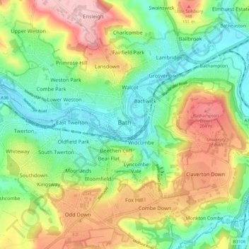
Name: Topografische Karte Bath, Höhe, Relief.
Durchschnittliche Höhe: 100 m
Minimale Höhe: 14 m
Maximale Höhe: 235 m
Spenden
Rüste dich für dein nächstes Abenteuer:
Als Amazon-Partner verdient diese Website an qualifizierten Käufen, ohne zusätzliche Kosten für Sie.
Andere topografische Karten
Klicken Sie auf eine Karte, um ihre Topografie, ihre Höhe und ihr Relief anzuzeigen.
Bathwick Hill
United Kingdom > England > Bath and North East Somerset > Bath
Number 1 (Bathwick Lodge) is a 2-storey villa with a steep Mansard room, built in 1825, extended in 1840 and the late C19. Probably by John Pinch the Elder.[4] Number 2 is from the early 19th century and has shutters over the windows.[11] Number 3 includes a porch which is elaborately enriched with carving,…
Durchschnittliche Höhe: 93 m
Hallatrow
United Kingdom > England > Bath and North East Somerset > High Littleton
Durchschnittliche Höhe: 119 m
Old Mills
United Kingdom > England > Bath and North East Somerset > Paulton
Durchschnittliche Höhe: 126 m
Norton Hawkfield
United Kingdom > England > Bath and North East Somerset > Norton Malreward
Durchschnittliche Höhe: 96 m
Spenden
Rüste dich für dein nächstes Abenteuer:
Als Amazon-Partner verdient diese Website an qualifizierten Käufen, ohne zusätzliche Kosten für Sie.
Amesbury
United Kingdom > England > Bath and North East Somerset > Timsbury
Durchschnittliche Höhe: 130 m
Knowle Hill
United Kingdom > England > Bath and North East Somerset > Chew Magna
Durchschnittliche Höhe: 65 m
Little Solsbury Hill
United Kingdom > England > Bath and North East Somerset > Batheaston
Durchschnittliche Höhe: 88 m
Monger
United Kingdom > England > Bath and North East Somerset > Midsomer Norton
Durchschnittliche Höhe: 118 m
Spenden
Rüste dich für dein nächstes Abenteuer:
Als Amazon-Partner verdient diese Website an qualifizierten Käufen, ohne zusätzliche Kosten für Sie.
Sharpstone
United Kingdom > England > Bath and North East Somerset > Freshford
Durchschnittliche Höhe: 93 m
Chewton Keynsham
United Kingdom > England > Bath and North East Somerset > Compton Dando
Durchschnittliche Höhe: 57 m
North Wick
United Kingdom > England > Bath and North East Somerset > Chew Magna
Durchschnittliche Höhe: 110 m
Carlingcott
United Kingdom > England > Bath and North East Somerset > Peasedown St. John
Durchschnittliche Höhe: 123 m
Spenden
Rüste dich für dein nächstes Abenteuer:
Als Amazon-Partner verdient diese Website an qualifizierten Käufen, ohne zusätzliche Kosten für Sie.
Tadwick
United Kingdom > England > Bath and North East Somerset > Swainswick
Durchschnittliche Höhe: 161 m
Pipehouse
United Kingdom > England > Bath and North East Somerset > Hinton Charterhouse
Durchschnittliche Höhe: 94 m
Sydney Gardens
United Kingdom > England > Bath and North East Somerset > Bath
Durchschnittliche Höhe: 75 m
Spenden
Rüste dich für dein nächstes Abenteuer:
Als Amazon-Partner verdient diese Website an qualifizierten Käufen, ohne zusätzliche Kosten für Sie.
Keynsham Memorial Park
United Kingdom > England > Bath and North East Somerset > Keynsham
Durchschnittliche Höhe: 29 m
Stoney Littleton
United Kingdom > England > Bath and North East Somerset > Shoscombe
Durchschnittliche Höhe: 116 m
Spenden
Rüste dich für dein nächstes Abenteuer:
Als Amazon-Partner verdient diese Website an qualifizierten Käufen, ohne zusätzliche Kosten für Sie.
Clutton Hill
United Kingdom > England > Bath and North East Somerset > Farmborough
Durchschnittliche Höhe: 133 m
Cholwell
United Kingdom > England > Bath and North East Somerset > Clutton
Durchschnittliche Höhe: 130 m
Spenden
Rüste dich für dein nächstes Abenteuer:
Als Amazon-Partner verdient diese Website an qualifizierten Käufen, ohne zusätzliche Kosten für Sie.
Park Corner
United Kingdom > England > Bath and North East Somerset > Freshford > Park Corner
Durchschnittliche Höhe: 93 m
Sydney Gardens
United Kingdom > England > Bath and North East Somerset > Bath
Durchschnittliche Höhe: 77 m
Wick Green
United Kingdom > England > Bath and North East Somerset > Bishop Sutton
Durchschnittliche Höhe: 82 m
Spenden
Rüste dich für dein nächstes Abenteuer:
Als Amazon-Partner verdient diese Website an qualifizierten Käufen, ohne zusätzliche Kosten für Sie.
Maes Knoll
United Kingdom > England > Bath and North East Somerset > Norton Malreward
Durchschnittliche Höhe: 110 m
Whitley Batts
United Kingdom > England > Bath and North East Somerset > Pensford
Durchschnittliche Höhe: 87 m
Mearns
United Kingdom > England > Bath and North East Somerset > Farmborough
Durchschnittliche Höhe: 129 m
Clandown
United Kingdom > England > Bath and North East Somerset > Radstock
Durchschnittliche Höhe: 118 m
Spenden
Rüste dich für dein nächstes Abenteuer:
Als Amazon-Partner verdient diese Website an qualifizierten Käufen, ohne zusätzliche Kosten für Sie.