
Topografische Karte Waddington
Interaktive Karte
Klicken Sie auf die Karte, um die Höhe anzuzeigen.
Über diese Karte
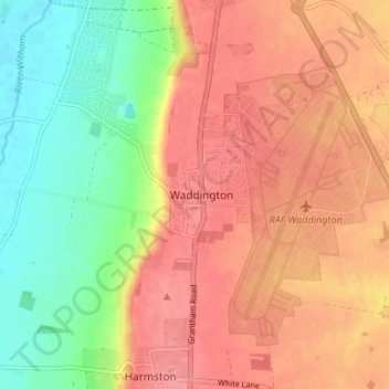
Name: Topografische Karte Waddington, Höhe, Relief.
Durchschnittliche Höhe: 41 m
Minimale Höhe: 4 m
Maximale Höhe: 91 m
During the Ice Age, most of the region surrounding Waddington was covered by ice sheets and this has influenced the topography and nature of the soils. Waddington's cliff-top position means it is 226 ft (69 m) above sea level, giving it commanding views over the River Witham valley.