
Topografische Karte Durham County
Interaktive Karte
Klicken Sie auf die Karte, um die Höhe anzuzeigen.
Über diese Karte
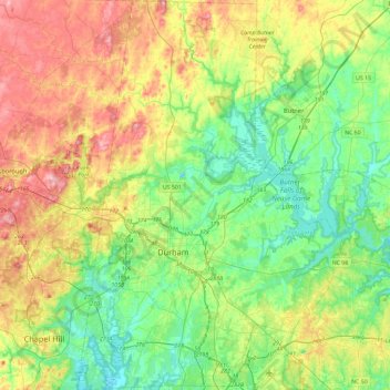
Name: Topografische Karte Durham County, Höhe, Relief.
Ort: Durham County, North Carolina, USA (35.86322 -79.01628 36.23931 -78.69929)
Durchschnittliche Höhe: 128 m
Minimale Höhe: 67 m
Maximale Höhe: 237 m
Andere topografische Karten
Klicken Sie auf eine Karte, um ihre Topografie, ihre Höhe und ihr Relief anzuzeigen.
Asheville
USA > North Carolina > Asheville
Asheville, Buncombe County, North Carolina, USA
Durchschnittliche Höhe: 727 m
Tar River
USA > North Carolina > Greenville
Tar River, Greenville, Pitt County, North Carolina, 27834, USA
Durchschnittliche Höhe: 6 m
Mitchell County
Mitchell County, North Carolina, USA
Durchschnittliche Höhe: 986 m
Allegheny
USA > North Carolina > Allegheny
Allegheny, Madison County, North Carolina, USA
Durchschnittliche Höhe: 797 m
Mount Mitchell
Mount Mitchell, Yancey County, North Carolina, USA
Durchschnittliche Höhe: 1.743 m
Kings Mountain
USA > North Carolina > Kings Mountain
Kings Mountain, Cleveland County, North Carolina, 28086, USA
Durchschnittliche Höhe: 272 m
Downs Mountain
Downs Mountain, Macon County, North Carolina, 28763, USA
Durchschnittliche Höhe: 732 m
Southern Nantahala Wilderness
Southern Nantahala Wilderness, Appalachian Trail, Macon County, North Carolina, USA
Durchschnittliche Höhe: 957 m