
Topografische Karte Ankeny
Interaktive Karte
Klicken Sie auf die Karte, um die Höhe anzuzeigen.
Über diese Karte
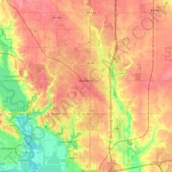
Name: Topografische Karte Ankeny, Höhe, Relief.
Ort: Ankeny, Polk County, Iowa, United States (41.65213 -93.67277 41.79132 -93.54144)
Durchschnittliche Höhe: 283 m
Minimale Höhe: 237 m
Maximale Höhe: 310 m
Like most of Polk County, Ankeny exists at the bottom area of the Des Moines Lobe, a topographical landscape area, in an area known as the Bemis Advance. The Lobe was formed during the Wisconsin glaciation leaving significant deposits resulting in an area with low relief.
Andere topografische Karten
Klicken Sie auf eine Karte, um ihre Topografie, ihre Höhe und ihr Relief anzuzeigen.
Des Moines
United States > Iowa > Polk County
Des Moines, Polk County, Iowa, United States
Durchschnittliche Höhe: 264 m
Clive
United States > Iowa > Polk County
Clive, Polk County, Iowa, 50325, United States
Durchschnittliche Höhe: 287 m
Polk City
United States > Iowa > Polk County > Polk City > Polk City
Polk City, Polk County, Iowa, 50226, United States
Durchschnittliche Höhe: 279 m
West Des Moines
United States > Iowa > Polk County
West Des Moines, Polk County, Iowa, United States
Durchschnittliche Höhe: 280 m
Des Moines
United States > Iowa > Polk County > Des Moines
Des Moines, Polk County, Iowa, 50319, United States
Durchschnittliche Höhe: 271 m