
Topografische Karte Baltimore
Interaktive Karte
Klicken Sie auf die Karte, um die Höhe anzuzeigen.
Über diese Karte
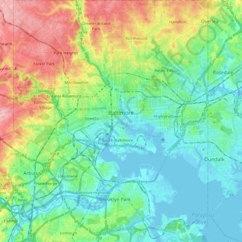
Name: Topografische Karte Baltimore, Höhe, Relief.
Ort: Baltimore, Maryland, USA (39.19723 -76.71130 39.37197 -76.52968)
Durchschnittliche Höhe: 51 m
Minimale Höhe: -5 m
Maximale Höhe: 158 m
Andere topografische Karten
Klicken Sie auf eine Karte, um ihre Topografie, ihre Höhe und ihr Relief anzuzeigen.
Ferry Road
USA > Maryland > Ferry Road
Ferry Road, Wicomico County, Maryland, 21810, USA
Durchschnittliche Höhe: 7 m
Williams Wharf
USA > Maryland > Williams Wharf
Williams Wharf, Calvert County, Maryland, 20615, USA
Durchschnittliche Höhe: 13 m
Grahams Green Acres
USA > Maryland > Grahams Green Acres
Grahams Green Acres, Carroll County, Maryland, 21776, USA
Durchschnittliche Höhe: 223 m
Pocomoke River
Pocomoke River, Worcester County, Maryland, 21863, USA
Durchschnittliche Höhe: 7 m