
Topografische Karte Glastenbury
Interaktive Karte
Klicken Sie auf die Karte, um die Höhe anzuzeigen.
Über diese Karte
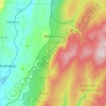
Name: Topografische Karte Glastenbury, Höhe, Relief.
Ort: Glastenbury, Bennington County, Vermont, United States (42.93025 -73.14600 43.02582 -73.00323)
Durchschnittliche Höhe: 740 m
Minimale Höhe: 292 m
Maximale Höhe: 1.142 m
Despite the many hardships that greeted Glastenbury settlers, newcomers continued to arrive in small numbers, and the population grew slowly to 76 in 1810. But the years following 1810 were hard ones for all of Vermont, and by 1840 there were only 53 left in Glastenbury. After the Civil War, Glastenbury finally began to experience more rapid growth. Business interests in nearby Bennington were eager to take advantage of the vast timber resources there, and by 1872 had finally begun construction on a railroad (trolley) which ran up the mountain. The line ran along Bolles Brook and terminated at the place where the brook forked. It was an improbable achievement, with some parts of the line climbing as much as 250 feet (76 m) in altitude per mile. Remains of the old trolley tracks can still be seen today.
Andere topografische Karten
Klicken Sie auf eine Karte, um ihre Topografie, ihre Höhe und ihr Relief anzuzeigen.
Stratton Acres
United States > Vermont > Bennington County > Winhall
Stratton Acres, Winhall, Bennington County, Vermont, 05340, United States
Durchschnittliche Höhe: 512 m
Pownal Center
United States > Vermont > Bennington County > Pownal
Pownal Center, Pownal, Bennington County, Vermont, 05261, United States
Durchschnittliche Höhe: 311 m
Arlington
United States > Vermont > Bennington County
Arlington, Bennington County, Vermont, 05250, United States
Durchschnittliche Höhe: 385 m
Peru
United States > Vermont > Bennington County
Peru, Bennington County, Vermont, 05152, United States
Durchschnittliche Höhe: 595 m
South Shaftsbury
United States > Vermont > Bennington County > Shaftsbury
South Shaftsbury, Shaftsbury, Bennington County, Vermont, 05262, United States
Durchschnittliche Höhe: 258 m
Sunderland
United States > Vermont > Bennington County
Sunderland, Bennington County, Vermont, 05252, United States
Durchschnittliche Höhe: 500 m
North Pownal
United States > Vermont > Bennington County > Pownal
North Pownal, Pownal, Bennington County, Vermont, 05260, United States
Durchschnittliche Höhe: 254 m
North Bennington
United States > Vermont > Bennington County > Bennington
North Bennington, Bennington, Bennington County, Vermont, 05257, United States
Durchschnittliche Höhe: 196 m
Shaftsbury
United States > Vermont > Bennington County > Shaftsbury
Shaftsbury, Bennington County, Vermont, 05262, United States
Durchschnittliche Höhe: 355 m
Sandgate
United States > Vermont > Bennington County
Sandgate, Bennington County, Vermont, United States
Durchschnittliche Höhe: 480 m
Bennington
United States > Vermont > Bennington County
Bennington, Bennington County, Vermont, United States
Durchschnittliche Höhe: 313 m
Landgrove
United States > Vermont > Bennington County > Landgrove
Landgrove, Bennington County, Vermont, 05152, United States
Durchschnittliche Höhe: 491 m
Manchester Center
United States > Vermont > Bennington County > Manchester
Manchester Center, Manchester, Bennington County, Vermont, 05255, United States
Durchschnittliche Höhe: 384 m
Bromley Mountain
United States > Vermont > Bennington County > Peru
Bromley Mountain, Peru, Bennington County, Vermont, 05152, United States
Durchschnittliche Höhe: 777 m
Green Mountain National Forest
United States > Vermont > Bennington County
Green Mountain National Forest, Bennington County, Vermont, United States
Durchschnittliche Höhe: 348 m
Gale Meadows Pond
United States > Vermont > Bennington County > Winhall > French Hollow
Gale Meadows Pond, French Hollow, Winhall, Bennington County, Vermont, United States
Durchschnittliche Höhe: 437 m
Manchester
United States > Vermont > Bennington County
Manchester, Bennington County, Vermont, United States
Durchschnittliche Höhe: 453 m
Dorset Quarry
United States > Vermont > Bennington County > Dorset
Dorset Quarry, Dorset, Bennington County, Vermont, United States
Durchschnittliche Höhe: 346 m
Arlington
United States > Vermont > Bennington County > Arlington
Arlington, Bennington County, Vermont, United States
Durchschnittliche Höhe: 282 m
Winhall
United States > Vermont > Bennington County
Winhall, Bennington County, Vermont, 05340, United States
Durchschnittliche Höhe: 578 m
Shaftsbury
United States > Vermont > Bennington County
Shaftsbury, Bennington County, Vermont, 05262, United States
Durchschnittliche Höhe: 395 m
Pownal
United States > Vermont > Bennington County
Pownal, Bennington County, Vermont, United States
Durchschnittliche Höhe: 369 m
Woodford
United States > Vermont > Bennington County
Woodford, Bennington County, Vermont, United States
Durchschnittliche Höhe: 670 m
Bondville
United States > Vermont > Bennington County > Winhall
Bondville, Winhall, Bennington County, Vermont, 05340, United States
Durchschnittliche Höhe: 486 m
Searsburg
United States > Vermont > Bennington County
Searsburg, Bennington County, Vermont, United States
Durchschnittliche Höhe: 675 m
Rupert
United States > Vermont > Bennington County
Rupert, Bennington County, Vermont, United States
Durchschnittliche Höhe: 360 m
Readsboro
United States > Vermont > Bennington County
Readsboro, Bennington County, Vermont, 05350, United States
Durchschnittliche Höhe: 596 m
Landgrove
United States > Vermont > Bennington County
Landgrove, Bennington County, Vermont, United States
Durchschnittliche Höhe: 479 m
Old Bennington
United States > Vermont > Bennington County > Bennington
Old Bennington, Bennington, Bennington County, Vermont, United States
Durchschnittliche Höhe: 245 m