
Topografische Karte Parc national de Banff
Interaktive Karte
Klicken Sie auf die Karte, um die Höhe anzuzeigen.
Über diese Karte
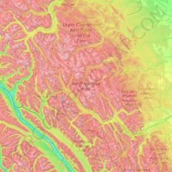
Name: Topografische Karte Parc national de Banff, Höhe, Relief.
Ort: Parc national de Banff, Alberta, Canada (50.70506 -117.31712 52.27145 -115.16491)
Durchschnittliche Höhe: 1.848 m
Minimale Höhe: 773 m
Maximale Höhe: 3.472 m
Le paysage de Banff est également marqué par l'érosion glaciaire, avec des vallées profondes en forme de U et de nombreuses vallées suspendues qui se terminent souvent en chute d'eau. Des montagnes à l'aspect pyramidal, telles que le mont Assiniboine, ont été façonnées par l'érosion glaciaire. De nombreuses petites gorges existent également, comme le canyon Mistaya et le canyon Johnston. L'altitude dans le parc varie de 1 350 m dans la vallée de la Bow à 3 618 m au sommet du mont Assiniboine.
Andere topografische Karten
Klicken Sie auf eine Karte, um ihre Topografie, ihre Höhe und ihr Relief anzuzeigen.
Canmore
Canada > Alberta > Division No. 15
Canmore, Division No. 15, Alberta, T1W 2H4, Canada
Durchschnittliche Höhe: 1.565 m
High River
Canada > Alberta > Town of High River
High River, Town of High River, Alberta, T1V 1R6, Canada
Durchschnittliche Höhe: 1.042 m
Pyramid Mountain
Canada > Alberta > Division No. 15 > Municipality of Jasper
Pyramid Mountain, Municipality of Jasper, Division No. 15, Alberta, Canada
Durchschnittliche Höhe: 2.152 m
Saskatchewan River Crossing
Canada > Alberta > Improvement District No. 9
Saskatchewan River Crossing, Improvement District No. 9, Alberta, Canada
Durchschnittliche Höhe: 1.443 m
Improvement District No. 9
Improvement District No. 9, Alberta, Canada
Durchschnittliche Höhe: 1.848 m
Hamlet of Monarch
Canada > Alberta > Lethbridge County
Hamlet of Monarch, Lethbridge County, Alberta, Canada
Durchschnittliche Höhe: 933 m
Brule Lake
Canada > Alberta > Yellowhead County > Brûlé
Brule Lake, Brûlé, Yellowhead County, Alberta, Canada
Durchschnittliche Höhe: 1.250 m
Vanrena
Canada > Alberta > Municipal District of Fairview
Vanrena, Municipal District of Fairview, Alberta, Canada
Durchschnittliche Höhe: 601 m
Mount Henday
Canada > Alberta > Improvement District No. 12
Mount Henday, Improvement District No. 12, Alberta, Canada
Durchschnittliche Höhe: 2.334 m
La Crete
Canada > Alberta > Mackenzie County
La Crete, Mackenzie County, Alberta, T0H 2H0, Canada
Durchschnittliche Höhe: 323 m
Cairngorm
Canada > Alberta > Municipality of Jasper
Cairngorm, Municipality of Jasper, Alberta, Canada
Durchschnittliche Höhe: 2.240 m
Cochrane
Canada > Alberta > Town of Cochrane > Cochrane
Cochrane, Town of Cochrane, Alberta, T4V 2A7, Canada
Durchschnittliche Höhe: 1.205 m
Prince's Island Park
Prince's Island Park, Eau Claire, Calgary, Alberta, T2P 0R1, Canada
Durchschnittliche Höhe: 1.065 m
City of Red Deer
Canada > Alberta > Division No. 8
City of Red Deer, Division No. 8, Alberta, Canada
Durchschnittliche Höhe: 890 m
Summer Village of Yellowstone
Canada > Alberta > Yellowstone (summer village) > Summer Village of Yellowstone
Summer Village of Yellowstone, Yellowstone (summer village), Alberta, Canada
Durchschnittliche Höhe: 733 m
Millet
Canada > Alberta > Town of Millet > Millet
Millet, Town of Millet, Alberta, T0C 1Z0, Canada
Durchschnittliche Höhe: 765 m
Crowsnest Pass (municipality)
Crowsnest Pass (municipality), Alberta, T0K 0M0, Canada
Durchschnittliche Höhe: 1.537 m
Grande Prairie
Canada > Alberta > Division No. 19
Grande Prairie, Division No. 19, Alberta, Canada
Durchschnittliche Höhe: 665 m
Comté de Strathcona
Canada > Alberta > Comté de Strathcona
Comté de Strathcona, Alberta, Canada
Durchschnittliche Höhe: 691 m
Town of Picture Butte
Town of Picture Butte, Alberta, T0K 1V0, Canada
Durchschnittliche Höhe: 905 m
Lake Louise
Canada > Alberta > Division No. 15
Lake Louise, Division No. 15, Alberta, Canada
Durchschnittliche Höhe: 1.617 m
Town of Pincher Creek
Town of Pincher Creek, Alberta, T0K 1W0, Canada
Durchschnittliche Höhe: 1.149 m
Avonmore
Canada > Alberta > Division No. 11
Avonmore, Mill Creek South, Division No. 11, Alberta, T6C 2N1, Canada
Durchschnittliche Höhe: 673 m
Medicine Hat
Canada > Alberta > Medicine Hat
Medicine Hat, Medicine Hat (city), Alberta, Canada
Durchschnittliche Höhe: 708 m
McLennan (town)
McLennan (town), Alberta, T0H 2L0, Canada
Durchschnittliche Höhe: 640 m
Drumheller (town)
Drumheller (town), Alberta, T0J 2V0, Canada
Durchschnittliche Höhe: 855 m
South Kootenay Pass
South Kootenay Pass, Mount Rowe to Sage Pass Route, Regional District of East Kootenay, Alberta, Canada
Durchschnittliche Höhe: 2.007 m
Kananaskis Improvement District
Kananaskis Improvement District, Alberta, Canada
Durchschnittliche Höhe: 1.740 m