
Topografische Karte Cle Elum
Interaktive Karte
Klicken Sie auf die Karte, um die Höhe anzuzeigen.
Über diese Karte
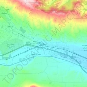
Name: Topografische Karte Cle Elum, Höhe, Relief.
Durchschnittliche Höhe: 697 m
Minimale Höhe: 561 m
Maximale Höhe: 1.058 m
Cle Elum has a humid continental climate, Köppen subtype Dsb. The elevation is 1909 feet and temperatures are cooler than areas to the east. The coldest month is December, a trait common in the Pacific Northwest. But hot temperatures still occur, and not just in summer: on March 18, 1968, the temperature soared to 95 °F.[17]
Andere topografische Karten
Klicken Sie auf eine Karte, um ihre Topografie, ihre Höhe und ihr Relief anzuzeigen.
Snoqualmie Pass
United States > Washington > Kittitas County
Snoqualmie Pass, Kittitas County, Washington, United States
Durchschnittliche Höhe: 955 m
Easton
United States > Washington > Kittitas County
Easton, Kittitas County, Washington, 98925, United States
Durchschnittliche Höhe: 742 m
Baldy Mountain
United States > Washington > Kittitas County
Baldy Mountain, Kittitas County, Washington, United States
Durchschnittliche Höhe: 674 m
Roslyn
United States > Washington > Kittitas County > Roslyn
Roslyn, Kittitas County, Washington, 98941, United States
Durchschnittliche Höhe: 742 m
Gold Creek Pond
United States > Washington > Kittitas County
Gold Creek Pond, Kittitas County, Washington, United States
Durchschnittliche Höhe: 905 m
Ellensburg
United States > Washington > Kittitas County
Ellensburg, Kittitas County, Washington, 98926, United States
Durchschnittliche Höhe: 480 m