
Topografische Karte Havana
Interaktive Karte
Klicken Sie auf die Karte, um die Höhe anzuzeigen.
Über diese Karte
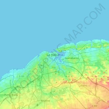
Name: Topografische Karte Havana, Höhe, Relief.
Ort: Havana, La Habana Vieja, Havana, 10000, Cuba (22.97531 -82.51896 23.29531 -82.19896)
Durchschnittliche Höhe: 30 m
Minimale Höhe: 0 m
Maximale Höhe: 196 m
There are low hills on which the city lies rise gently from the waters of the straits. A noteworthy elevation is the 200-foot-high (60-meter) limestone ridge that slopes up from the east and culminates in the heights of La Cabaña and El Morro, the sites of Spanish fortifications overlooking the eastern bay. Another notable rise is the hill to the west that is occupied by the University of Havana and the Castillo del Príncipe (Havana).