
Spenden
Rüste dich für dein nächstes Abenteuer:
Als Amazon-Partner verdient diese Website an qualifizierten Käufen, ohne zusätzliche Kosten für Sie.
Topografische Karte Beef Basin Wash
Klicken Sie auf die Karte, um die Höhe anzuzeigen.
Spenden
Rüste dich für dein nächstes Abenteuer:
Als Amazon-Partner verdient diese Website an qualifizierten Käufen, ohne zusätzliche Kosten für Sie.
Über diese Karte
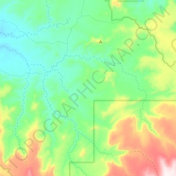
Name: Topografische Karte Beef Basin Wash, Höhe, Relief.
Ort: Beef Basin Wash, San Juan County, Utah, United States (37.90784 -109.94322 37.96761 -109.81280)
Durchschnittliche Höhe: 2.088 m
Minimale Höhe: 1.858 m
Maximale Höhe: 2.636 m
Spenden
Rüste dich für dein nächstes Abenteuer:
Als Amazon-Partner verdient diese Website an qualifizierten Käufen, ohne zusätzliche Kosten für Sie.
Andere topografische Karten
Klicken Sie auf eine Karte, um ihre Topografie, ihre Höhe und ihr Relief anzuzeigen.
Lake Powell
United States > Utah > San Juan County
Concrete placement started around the clock on June 17, 1960. The last bucket of concrete was poured on September 13, 1963. Over 5 million cubic yards (4,000,000 m³) of concrete make up Glen Canyon Dam. The dam is 710 feet (216 m) high and the surface elevation of the water at full-pool is approximately 3700…
Durchschnittliche Höhe: 1.555 m
Oljato–Monument Valley
United States > Utah > San Juan County
Oljato–Monument Valley is located at 37°0′38″N 110°14′34″W / 37.01056°N 110.24278°W / 37.01056; -110.24278 (37.010556, -110.242778), at an elevation of 1,475 m (4,840 feet).
Durchschnittliche Höhe: 1.557 m
Spenden
Rüste dich für dein nächstes Abenteuer:
Als Amazon-Partner verdient diese Website an qualifizierten Käufen, ohne zusätzliche Kosten für Sie.
Monticello
United States > Utah > San Juan County
Monticello is located at the base of the Abajo Mountains, or the Blue Mountains, which are part of the Manti-La Sal National Forest. The elevation of Monticello is 7,069 feet (2,155 m). From Monticello, a tree formation on the Blue Mountains can be seen, which resembles a horse's head and neck, which can be…
Durchschnittliche Höhe: 2.145 m
Rainbow Bridge National Monument
United States > Utah > San Juan County
Durchschnittliche Höhe: 1.288 m
Spenden
Rüste dich für dein nächstes Abenteuer:
Als Amazon-Partner verdient diese Website an qualifizierten Käufen, ohne zusätzliche Kosten für Sie.
Navajo Mountain
United States > Utah > San Juan County > Navajo Mountain
Durchschnittliche Höhe: 1.806 m
Fish Creek Canyon Wilderness Study Area
United States > Utah > San Juan County
Durchschnittliche Höhe: 1.817 m
Spenden
Rüste dich für dein nächstes Abenteuer:
Als Amazon-Partner verdient diese Website an qualifizierten Käufen, ohne zusätzliche Kosten für Sie.