
Topografische Karte Siskiyou Gap
Interaktive Karte
Klicken Sie auf die Karte, um die Höhe anzuzeigen.
Über diese Karte
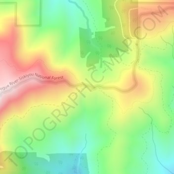
Name: Topografische Karte Siskiyou Gap, Höhe, Relief.
Ort: Siskiyou Gap, Jackson County, Oregon, United States (42.05046 -122.80636 42.05056 -122.80626)
Durchschnittliche Höhe: 1.746 m
Minimale Höhe: 1.485 m
Maximale Höhe: 2.076 m
"The original pass crosses the divide between the Rogue and Klamath Rivers at a slight topographic notch formed by the geological contact between the older Siskiyou Mountains to the west and the younger volcanic Cascade Range to the east." (Jeffrey M. LaLande, retired, forest archaeologist, Rogue River-Siskiyou National Forest)
Andere topografische Karten
Klicken Sie auf eine Karte, um ihre Topografie, ihre Höhe und ihr Relief anzuzeigen.
Ashland
United States > Oregon > Jackson County
Ashland, Jackson County, Oregon, United States
Durchschnittliche Höhe: 774 m
Trail
United States > Oregon > Jackson County
Trail, Jackson County, Oregon, 97539, United States
Durchschnittliche Höhe: 534 m
Ruch
United States > Oregon > Jackson County
Ruch, Jackson County, Oregon, United States
Durchschnittliche Höhe: 560 m
Medford
United States > Oregon > Jackson County
Medford, Jackson County, Oregon, United States
Durchschnittliche Höhe: 441 m
Applegate
United States > Oregon > Jackson County
Applegate, Jackson County, Oregon, United States
Durchschnittliche Höhe: 501 m
White City
United States > Oregon > Jackson County
White City, Jackson County, Oregon, 97503, United States
Durchschnittliche Höhe: 404 m
Fish Lake
United States > Oregon > Jackson County
Fish Lake, Jackson County, Oregon, United States
Durchschnittliche Höhe: 1.456 m
Shady Cove
United States > Oregon > Jackson County
Shady Cove, Jackson County, Oregon, 97539, United States
Durchschnittliche Höhe: 506 m
Eagle Point
United States > Oregon > Jackson County
Eagle Point, Jackson County, Oregon, 97524, United States
Durchschnittliche Höhe: 422 m
Central Point
United States > Oregon > Jackson County
Central Point, Jackson County, Oregon, 97502, United States
Durchschnittliche Höhe: 385 m
Lost Creek Lake
United States > Oregon > Jackson County
Lost Creek Lake, Jackson County, Oregon, United States
Durchschnittliche Höhe: 729 m
Buncom
United States > Oregon > Jackson County
Buncom, Jackson County, Oregon, United States
Durchschnittliche Höhe: 654 m
Mount Ashland
United States > Oregon > Jackson County
Mount Ashland, Jackson County, Oregon, United States
Durchschnittliche Höhe: 1.957 m
Rogue River
United States > Oregon > Jackson County
Rogue River, Jackson County, Oregon, 97537, United States
Durchschnittliche Höhe: 362 m
Phoenix
United States > Oregon > Jackson County
Phoenix, Jackson County, Oregon, 97535, United States
Durchschnittliche Höhe: 469 m
Wagner Butte
United States > Oregon > Jackson County
Wagner Butte, Jackson County, Oregon, United States
Durchschnittliche Höhe: 1.848 m
Gold Hill
United States > Oregon > Jackson County
Gold Hill, Jackson County, Oregon, United States
Durchschnittliche Höhe: 416 m
Talent
United States > Oregon > Jackson County
Talent, Jackson County, Oregon, United States
Durchschnittliche Höhe: 516 m
Jacksonville
United States > Oregon > Jackson County
Jacksonville, Jackson County, Oregon, 97530, United States
Durchschnittliche Höhe: 522 m