
Topografische Karte Atlantic Coastal Plain
Interaktive Karte
Klicken Sie auf die Karte, um die Höhe anzuzeigen.
Über diese Karte
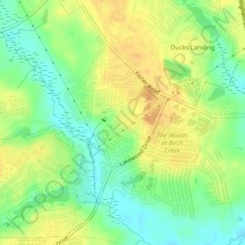
Name: Topografische Karte Atlantic Coastal Plain, Höhe, Relief.
Durchschnittliche Höhe: 51 m
Minimale Höhe: 34 m
Maximale Höhe: 66 m
The province's average elevation is less than 900 meters above sea level and extends some 50 to 100 kilometers inland from the ocean. The coastal plain is normally wet, including many rivers, marsh, and swampland. It is composed primarily of sedimentary rock and unlithified sediments and is primarily used for agriculture. The Atlantic Coastal Plain includes the Carolina Sandhills region as well as the Embayed and Sea Island physiographic provinces. The Atlantic Coastal Plain is sometimes subdivided into northern and southern regions, specifically the Mid-Atlantic and South Atlantic coastal plains.
Andere topografische Karten
Klicken Sie auf eine Karte, um ihre Topografie, ihre Höhe und ihr Relief anzuzeigen.
Rivercliff
United States > North Carolina > Cumberland County > Fayetteville
Rivercliff, Fayetteville, Cumberland County, North Carolina, 28301, United States
Durchschnittliche Höhe: 42 m
Bordeaux
United States > North Carolina > Cumberland County > Fayetteville
Bordeaux, Fayetteville, Cumberland County, North Carolina, 28248, United States
Durchschnittliche Höhe: 59 m
Fenix
United States > North Carolina > Cumberland County > Fayetteville
Fenix, Fayetteville, Cumberland County, North Carolina, 28314, United States
Durchschnittliche Höhe: 62 m
Cade Hill
United States > North Carolina > Cumberland County > Fayetteville
Cade Hill, Fayetteville, Cumberland County, North Carolina, United States
Durchschnittliche Höhe: 26 m
Blounts Creek
United States > North Carolina > Cumberland County > Fayetteville
Blounts Creek, Fayetteville, Cumberland County, North Carolina, 28301, United States
Durchschnittliche Höhe: 29 m
Owens
United States > North Carolina > Cumberland County > Fayetteville > Owens
Owens, Fayetteville, Cumberland County, North Carolina, 28305, United States
Durchschnittliche Höhe: 61 m