
Topografische Karte Portgordon
Interaktive Karte
Klicken Sie auf die Karte, um die Höhe anzuzeigen.
Über diese Karte
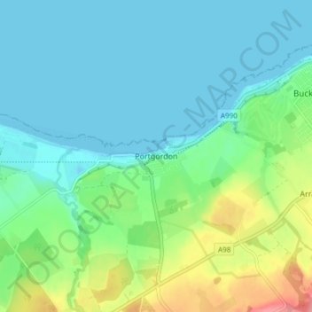
Name: Topografische Karte Portgordon, Höhe, Relief.
Ort: Portgordon, Moray, Scotland, AB56 5TL, United Kingdom (57.64349 -3.03604 57.68349 -2.99604)
Durchschnittliche Höhe: 22 m
Minimale Höhe: -2 m
Maximale Höhe: 89 m
Andere topografische Karten
Klicken Sie auf eine Karte, um ihre Topografie, ihre Höhe und ihr Relief anzuzeigen.
Garmouth
United Kingdom > Scotland > Moray
Garmouth, Moray, Scotland, IV32 7PD, United Kingdom
Durchschnittliche Höhe: 11 m
Dyke
United Kingdom > Scotland > Moray
Dyke, Moray, Scotland, IV36 2TJ, United Kingdom
Durchschnittliche Höhe: 24 m
Findhorn
United Kingdom > Scotland > Moray
Findhorn, Moray, Scotland, IV36 3YG, United Kingdom
Durchschnittliche Höhe: 3 m
Forres
United Kingdom > Scotland > Moray
Forres, Moray, Scotland, IV36 1NX, United Kingdom
Durchschnittliche Höhe: 31 m
Dunphail
United Kingdom > Scotland > Moray
Dunphail, Moray, Scotland, IV36 2QQ, United Kingdom
Durchschnittliche Höhe: 192 m