
Topografische Karte The Quill
Interaktive Karte
Klicken Sie auf die Karte, um die Höhe anzuzeigen.
Über diese Karte
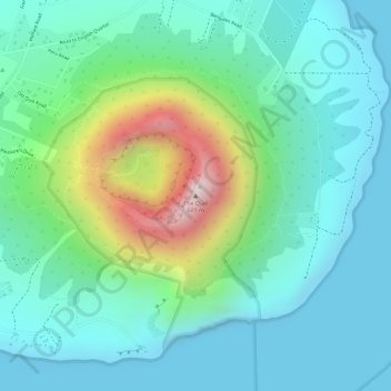
Name: Topografische Karte The Quill, Höhe, Relief.
Ort: The Quill, Sint Eustatius, Caribisch Nederland, Nederland (17.47613 -62.95999 17.47623 -62.95989)
Durchschnittliche Höhe: 143 m
Minimale Höhe: 0 m
Maximale Höhe: 559 m
Andere topografische Karten
Klicken Sie auf eine Karte, um ihre Topografie, ihre Höhe und ihr Relief anzuzeigen.
Sint Eustatius
Nederland > Caribisch Nederland
Sint Eustatius, Caribisch Nederland, Nederland
Durchschnittliche Höhe: 48 m
Sint Eustatius
Nederland > Caribisch Nederland
Sint Eustatius, Caribisch Nederland, Nederland
Durchschnittliche Höhe: 8 m
Washington-Slagbaai National Park
Nederland > Caribisch Nederland > Bonaire
Washington-Slagbaai National Park, Bonaire, Caribisch Nederland, Nederland
Durchschnittliche Höhe: 45 m