
Topografische Karte Avis
Interaktive Karte
Klicken Sie auf die Karte, um die Höhe anzuzeigen.
Über diese Karte
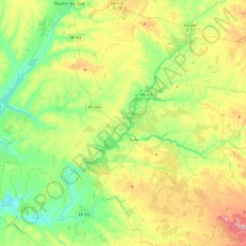
Name: Topografische Karte Avis, Höhe, Relief.
Ort: Avis, Portalegre, Alto Alentejo, Alentejo, Portugal (38.94077 -8.15200 39.21862 -7.69667)
Durchschnittliche Höhe: 171 m
Minimale Höhe: 56 m
Maximale Höhe: 389 m
Andere topografische Karten
Klicken Sie auf eine Karte, um ihre Topografie, ihre Höhe und ihr Relief anzuzeigen.
Vidigueira
Vidigueira, Beja, Baixo Alentejo, Alentejo, Portugal
Durchschnittliche Höhe: 191 m
Santiago do Cacém
Portugal > Alentejo > Santiago do Cacém, Santa Cruz e São Bartolomeu da Serra
Santiago do Cacém, Santiago do Cacém, Santa Cruz e São Bartolomeu da Serra, STC, Setúbal, Alentejo Litoral, Alentejo, Portugal
Durchschnittliche Höhe: 140 m
Paul do Boquilobo Nature Reserve
Portugal > Alentejo > Azinhaga
Paul do Boquilobo Nature Reserve, Estrada dos Lazaros, Azinhaga, Golegã, Santarém, Lezíria do Tejo, Alentejo, 2140-999, Portugal
Durchschnittliche Höhe: 27 m