
Topografische Karte Cuddalore
Klicken Sie auf die Karte, um die Höhe anzuzeigen.
Cuddalore
Cuddalore is located at 11°45′N 79°45′E / 11.75°N 79.75°E / 11.75; 79.75. It has an average elevation of 6 m (20 ft). The land is completely flat with large black and alluvial soil inland and coarse sand near the seashore. The sandstone deposits in the town are popular. The Pennayar River runs north of the town, while Gadilam River runs across it. Cuddalore is situated at 200 km (120 mi) from the state capital Chennai and 18 km (11 mi) from Puducherry, the neighbouring union territory.
Über diese Karte
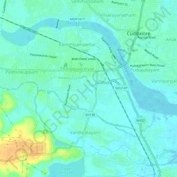
Name: Topografische Karte Cuddalore, Höhe, Relief.
Ort: Cuddalore, Cuddalore District, Tamil Nadu, 607002, India (11.72623 79.72313 11.75814 79.76974)
Durchschnittliche Höhe: 8 m
Minimale Höhe: -1 m
Maximale Höhe: 32 m
Andere topografische Karten
Klicken Sie auf eine Karte, um ihre Topografie, ihre Höhe und ihr Relief anzuzeigen.
Cuddalore
India > Tamil Nadu > Cuddalore
Cuddalore is located at 11°45′N 79°45′E / 11.75°N 79.75°E / 11.75; 79.75. It has an average elevation of 6 m (20 ft). The land is completely flat with large black and alluvial soil inland and coarse sand near the seashore. The sandstone deposits in the town are popular. The Pennayar River runs north of…
Durchschnittliche Höhe: 11 m