
Topografische Karte Clymer
Interaktive Karte
Klicken Sie auf die Karte, um die Höhe anzuzeigen.
Über diese Karte
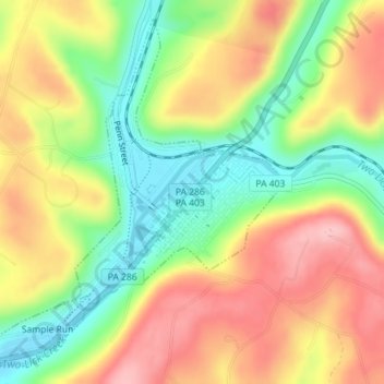
Name: Topografische Karte Clymer, Höhe, Relief.
Ort: Clymer, Indiana County, Pennsylvania, United States (40.65794 -79.02810 40.68249 -79.00130)
Durchschnittliche Höhe: 443 m
Minimale Höhe: 367 m
Maximale Höhe: 519 m
Andere topografische Karten
Klicken Sie auf eine Karte, um ihre Topografie, ihre Höhe und ihr Relief anzuzeigen.
Creekside
United States > Pennsylvania > Indiana County
Creekside, Indiana County, Pennsylvania, United States
Durchschnittliche Höhe: 360 m
Center Township
United States > Pennsylvania > Indiana County
Center Township, Indiana County, Pennsylvania, United States
Durchschnittliche Höhe: 390 m
Green Township
United States > Pennsylvania > Indiana County
Green Township, Indiana County, Pennsylvania, United States
Durchschnittliche Höhe: 495 m
Coy Junction
United States > Pennsylvania > Indiana County > Homer City
Coy Junction, Homer City, Indiana County, Pennsylvania, 15748, United States
Durchschnittliche Höhe: 368 m
Indiana
United States > Pennsylvania > Indiana County > Indiana
Indiana, Indiana County, Pennsylvania, United States
Durchschnittliche Höhe: 407 m