
Topografische Karte Chapel Hill
Interaktive Karte
Klicken Sie auf die Karte, um die Höhe anzuzeigen.
Über diese Karte
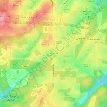
Name: Topografische Karte Chapel Hill, Höhe, Relief.
Ort: Chapel Hill, Douglas County, Georgia, 30135, United States (33.66701 -84.73595 33.70701 -84.69595)
Durchschnittliche Höhe: 296 m
Minimale Höhe: 238 m
Maximale Höhe: 348 m
Andere topografische Karten
Klicken Sie auf eine Karte, um ihre Topografie, ihre Höhe und ihr Relief anzuzeigen.
Winston
United States > Georgia > Douglas County
Winston, Douglas County, Georgia, 30187, United States
Durchschnittliche Höhe: 340 m
Tyree
United States > Georgia > Douglas County
Tyree, Douglas County, Georgia, United States
Durchschnittliche Höhe: 346 m
Douglasville
United States > Georgia > Douglas County
Douglasville, Douglas County, Georgia, 30133, United States
Durchschnittliche Höhe: 310 m
Andy Mountain
United States > Georgia > Douglas County
Andy Mountain, Douglas County, Georgia, 30187, United States
Durchschnittliche Höhe: 344 m
Sweetwater Creek State Park
United States > Georgia > Douglas County
Sweetwater Creek State Park, Douglas County, Georgia, 30122, United States
Durchschnittliche Höhe: 288 m
Lithia Springs
United States > Georgia > Douglas County
Lithia Springs, Douglas County, Georgia, 30122, United States
Durchschnittliche Höhe: 295 m
Douglas Estates
United States > Georgia > Douglas County > Douglas Estates
Douglas Estates, Douglas County, Georgia, 30135, United States
Durchschnittliche Höhe: 292 m