
Topografische Karte Jimena de la Frontera
Interaktive Karte
Klicken Sie auf die Karte, um die Höhe anzuzeigen.
Über diese Karte
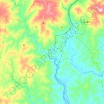
Name: Topografische Karte Jimena de la Frontera, Höhe, Relief.
Durchschnittliche Höhe: 269 m
Minimale Höhe: 14 m
Maximale Höhe: 1.001 m
Jimena de la Frontera enjoys a moderate Mediterranean climate. There are 3,000 hours of sunshine per year, which contributes to average temperatures of between 18 and 20 °C (64 and 68 °F). However, the rainfall pattern differs significantly from the rest of southern Spain, due to the topography of the Strait of Gibraltar region, which is swept by east and west winds that bring humidity and, therefore, rainfall averaging 900 to 1,000 mm (35 to 39 in).
Andere topografische Karten
Klicken Sie auf eine Karte, um ihre Topografie, ihre Höhe und ihr Relief anzuzeigen.
Los Barrios
Spain > Andalusia > Campo de Gibraltar
Los Barrios, Campo de Gibraltar, Cádiz, Andalusia, Spain
Durchschnittliche Höhe: 164 m
Campo de Gibraltar
Spain > Andalusia > Campo de Gibraltar
Campo de Gibraltar, Cádiz, Andalusia, Spain
Durchschnittliche Höhe: 149 m