
Topografische Karte County Down
Interaktive Karte
Klicken Sie auf die Karte, um die Höhe anzuzeigen.
Über diese Karte
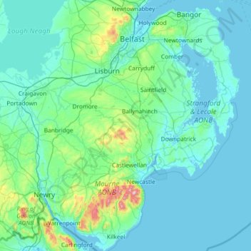
Name: Topografische Karte County Down, Höhe, Relief.
Ort: County Down, Northern Ireland, United Kingdom (54.02289 -6.40037 54.69924 -5.42682)
Durchschnittliche Höhe: 65 m
Minimale Höhe: -3 m
Maximale Höhe: 839 m
Andere topografische Karten
Klicken Sie auf eine Karte, um ihre Topografie, ihre Höhe und ihr Relief anzuzeigen.
Newry
United Kingdom > Northern Ireland > County Down
Newry, County Down, Northern Ireland, United Kingdom
Durchschnittliche Höhe: 73 m
Dundonald
United Kingdom > Northern Ireland > County Down
Dundonald, County Down, Ulster, Northern Ireland, BT16 1RH, United Kingdom
Durchschnittliche Höhe: 80 m
Killough
United Kingdom > Northern Ireland > County Down
Killough, County Down, Ulster, Northern Ireland, BT30 7QQ, United Kingdom
Durchschnittliche Höhe: 7 m
Ballynahinch
United Kingdom > Northern Ireland > County Down > Ballynahinch
Ballynahinch, County Down, Ulster, Northern Ireland, BT24 8DN, United Kingdom
Durchschnittliche Höhe: 99 m
Lawrencetown
United Kingdom > Northern Ireland > County Down
Lawrencetown, County Down, Northern Ireland, BT63 6DU, United Kingdom
Durchschnittliche Höhe: 72 m
Saintfield
United Kingdom > Northern Ireland > County Down
Saintfield, County Down, Ulster, Northern Ireland, BT24 7AA, United Kingdom
Durchschnittliche Höhe: 87 m