
Topografische Karte Bloomfield
Interaktive Karte
Klicken Sie auf die Karte, um die Höhe anzuzeigen.
Über diese Karte
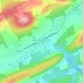
Name: Topografische Karte Bloomfield, Höhe, Relief.
Ort: Bloomfield, Perry County, Pennsylvania, United States (40.41275 -77.20040 40.42578 -77.17727)
Durchschnittliche Höhe: 236 m
Minimale Höhe: 183 m
Maximale Höhe: 330 m
Andere topografische Karten
Klicken Sie auf eine Karte, um ihre Topografie, ihre Höhe und ihr Relief anzuzeigen.
Liverpool
United States > Pennsylvania > Perry County
Liverpool, Perry County, Pennsylvania, 17045, United States
Durchschnittliche Höhe: 148 m
Loysville
United States > Pennsylvania > Perry County > Loysville
Loysville, Perry County, Pennsylvania, 17047, United States
Durchschnittliche Höhe: 197 m
Buffalo Mountain
United States > Pennsylvania > Perry County
Buffalo Mountain, Perry County, Pennsylvania, United States
Durchschnittliche Höhe: 250 m
New Bloomfield
United States > Pennsylvania > Perry County > New Bloomfield
New Bloomfield, Perry County, Pennsylvania, 17068, United States
Durchschnittliche Höhe: 238 m
Shermans Dale
United States > Pennsylvania > Perry County
Shermans Dale, Perry County, Pennsylvania, 17090, United States
Durchschnittliche Höhe: 171 m