
Topografische Karte Radium Springs
Interaktive Karte
Klicken Sie auf die Karte, um die Höhe anzuzeigen.
Über diese Karte
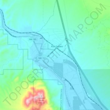
Name: Topografische Karte Radium Springs, Höhe, Relief.
Ort: Radium Springs, Doña Ana County, New Mexico, United States (32.44523 -106.92951 32.52452 -106.87740)
Durchschnittliche Höhe: 1.278 m
Minimale Höhe: 1.199 m
Maximale Höhe: 1.707 m
Andere topografische Karten
Klicken Sie auf eine Karte, um ihre Topografie, ihre Höhe und ihr Relief anzuzeigen.
Las Cruces
United States > New Mexico > Doña Ana County
Las Cruces, Doña Ana County, New Mexico, United States
Durchschnittliche Höhe: 1.297 m
Riley Black Standpipe, Mount
United States > New Mexico > Doña Ana County
Riley Black Standpipe, Mount, Doña Ana County, New Mexico, United States
Durchschnittliche Höhe: 1.254 m