
Topografische Karte Long Pond
Interaktive Karte
Klicken Sie auf die Karte, um die Höhe anzuzeigen.
Long Pond
Long Pond is named after the unique wetland topography formed by the Tunkhannock Creek. Within the Long Pond community, public access lands are owned and protected by The Bethlehem Authority, Nature Conservancy, Wildlands Conservancy County of Monroe Open Space Program, , PA Game Commission and PA Department of Forest and Waters. Long Pond is home to many species of unique plants and animals.
Über diese Karte
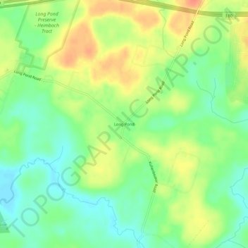
Name: Topografische Karte Long Pond, Höhe, Relief.
Durchschnittliche Höhe: 571 m
Minimale Höhe: 550 m
Maximale Höhe: 596 m
Andere topografische Karten
Klicken Sie auf eine Karte, um ihre Topografie, ihre Höhe und ihr Relief anzuzeigen.
Indian Mountain Lake
United States > Pennsylvania > Monroe County > Tunkhannock Township > Indian Mountain Lake
Durchschnittliche Höhe: 506 m