
Spenden
Rüste dich für dein nächstes Abenteuer:
Als Amazon-Partner verdient diese Website an qualifizierten Käufen, ohne zusätzliche Kosten für Sie.
Topografische Karte Lytton
Klicken Sie auf die Karte, um die Höhe anzuzeigen.
Spenden
Rüste dich für dein nächstes Abenteuer:
Als Amazon-Partner verdient diese Website an qualifizierten Käufen, ohne zusätzliche Kosten für Sie.
Lytton
Lytton experiences an inland hot-summer mediterranean climate (Csa), using the -3 °C isotherm, or a dry-summer continental climate (Dsa), using the 0 °C isotherm. During summer heat waves, Lytton is often the hottest spot in Canada, despite its location north of 50°N in latitude. Because of the dry summer air and a relatively low elevation of 195 m (640 ft), summer afternoon shade temperatures frequently reach 35 °C (95 °F) and occasionally top 40 °C (104 °F). Lytton holds the record for the highest temperature ever recorded in Canada with a record high of 49.6 °C (121.3 °F) on June 29 of the 2021 Western North America heat wave. This occurred after having already broken records multiple times during the previous days of that heat wave. This is the world's highest temperature ever recorded north of the 45th parallel. The previous record was 121 °F (49.4 °C) in Steele, North Dakota on July 6, 1936. Lytton has recorded a higher temperature than all but 4 U.S. states, with only Arizona, California, New Mexico, and Nevada ever recording higher temperatures. Lytton has also recorded higher temperatures than all of Europe and South America have ever recorded.
Spenden
Rüste dich für dein nächstes Abenteuer:
Als Amazon-Partner verdient diese Website an qualifizierten Käufen, ohne zusätzliche Kosten für Sie.
Über diese Karte
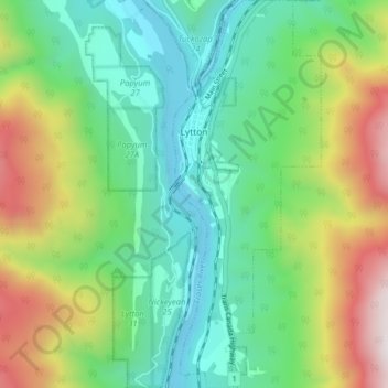
Name: Topografische Karte Lytton, Höhe, Relief.
Durchschnittliche Höhe: 523 m
Minimale Höhe: 126 m
Maximale Höhe: 1.359 m
Spenden
Rüste dich für dein nächstes Abenteuer:
Als Amazon-Partner verdient diese Website an qualifizierten Käufen, ohne zusätzliche Kosten für Sie.
Andere topografische Karten
Klicken Sie auf eine Karte, um ihre Topografie, ihre Höhe und ihr Relief anzuzeigen.
Spider Lake
Canada > British Columbia > Thompson-Nicola Regional District > Area O (Lower North Thompson)
Durchschnittliche Höhe: 1.358 m
Kamloops
Canada > British Columbia > Thompson-Nicola Regional District > Kamloops
Durchschnittliche Höhe: 875 m
Bleeker Lake
Canada > British Columbia > Thompson-Nicola Regional District > Area L (Grasslands)
Durchschnittliche Höhe: 1.148 m
Ernest Lake
Canada > British Columbia > Thompson-Nicola Regional District > Area L (Grasslands)
Durchschnittliche Höhe: 1.260 m
Spenden
Rüste dich für dein nächstes Abenteuer:
Als Amazon-Partner verdient diese Website an qualifizierten Käufen, ohne zusätzliche Kosten für Sie.
Paul Lake
Canada > British Columbia > Thompson-Nicola Regional District > Area P (Rivers and the Peaks)
Durchschnittliche Höhe: 926 m
Clifford Lake
Canada > British Columbia > Thompson-Nicola Regional District > Area N (Beautiful Nicola Valley - South)
Durchschnittliche Höhe: 1.085 m
Savona
Canada > British Columbia > Thompson-Nicola Regional District > Area J (Copper Desert Country)
Durchschnittliche Höhe: 480 m
Sun Peaks
Canada > British Columbia > Thompson-Nicola Regional District > Sun Peaks Mountain Resort Municipality
Durchschnittliche Höhe: 1.490 m
Spenden
Rüste dich für dein nächstes Abenteuer:
Als Amazon-Partner verdient diese Website an qualifizierten Käufen, ohne zusätzliche Kosten für Sie.
Powerline Lake
Canada > British Columbia > Thompson-Nicola Regional District > Area L (Grasslands)
Durchschnittliche Höhe: 1.215 m
Monte Lake
Canada > British Columbia > Thompson-Nicola Regional District > Area L (Grasslands)
Durchschnittliche Höhe: 862 m
Eleanor Lake
Canada > British Columbia > Thompson-Nicola Regional District > Area B (Thompson Headwaters) > Blue River
Durchschnittliche Höhe: 695 m
Jacko Lake
Canada > British Columbia > Thompson-Nicola Regional District > Area J (Copper Desert Country)
Durchschnittliche Höhe: 931 m
Spenden
Rüste dich für dein nächstes Abenteuer:
Als Amazon-Partner verdient diese Website an qualifizierten Käufen, ohne zusätzliche Kosten für Sie.
Snohoosh Lake
Canada > British Columbia > Thompson-Nicola Regional District > Area J (Copper Desert Country)
Durchschnittliche Höhe: 1.000 m
Stake Lake
Canada > British Columbia > Thompson-Nicola Regional District > Area J (Copper Desert Country)
Durchschnittliche Höhe: 1.351 m
70 Mile House
Canada > British Columbia > Thompson-Nicola Regional District > Area E (Bonaparte Plateau)
Durchschnittliche Höhe: 1.087 m
Mount Cahilty
Canada > British Columbia > Thompson-Nicola Regional District > Area O (Lower North Thompson)
Durchschnittliche Höhe: 1.736 m
Spenden
Rüste dich für dein nächstes Abenteuer:
Als Amazon-Partner verdient diese Website an qualifizierten Käufen, ohne zusätzliche Kosten für Sie.
Whitecroft
Canada > British Columbia > Thompson-Nicola Regional District > Area P (Rivers and the Peaks)
Durchschnittliche Höhe: 1.000 m
Pinantan Lake
Canada > British Columbia > Thompson-Nicola Regional District > Area P (Rivers and the Peaks)
Durchschnittliche Höhe: 971 m
Dominic Lake
Canada > British Columbia > Thompson-Nicola Regional District > Area J (Copper Desert Country)
Durchschnittliche Höhe: 1.583 m
Cultus Lake
Canada > British Columbia > Thompson-Nicola Regional District > Area J (Copper Desert Country)
Durchschnittliche Höhe: 1.033 m
Spenden
Rüste dich für dein nächstes Abenteuer:
Als Amazon-Partner verdient diese Website an qualifizierten Käufen, ohne zusätzliche Kosten für Sie.
Drum Lake
Canada > British Columbia > Thompson-Nicola Regional District > Area M (Beautiful Nicola Valley - North)
Durchschnittliche Höhe: 1.166 m
Kingsvale
Canada > British Columbia > Thompson-Nicola Regional District > Area N (Beautiful Nicola Valley - South)
Durchschnittliche Höhe: 928 m
Leonie Lake
Canada > British Columbia > Thompson-Nicola Regional District > Area O (Lower North Thompson)
Durchschnittliche Höhe: 1.107 m
Little Fort
Canada > British Columbia > Thompson-Nicola Regional District > Area O (Lower North Thompson)
Durchschnittliche Höhe: 521 m
Spenden
Rüste dich für dein nächstes Abenteuer:
Als Amazon-Partner verdient diese Website an qualifizierten Käufen, ohne zusätzliche Kosten für Sie.
Lower Nicola
Canada > British Columbia > Thompson-Nicola Regional District > Area M (Beautiful Nicola Valley - North)
Durchschnittliche Höhe: 649 m
Vavenby
Canada > British Columbia > Thompson-Nicola Regional District > Area A (Wells Gray Country)
Durchschnittliche Höhe: 642 m
South Thompson River
Canada > British Columbia > Thompson-Nicola Regional District > Kamloops
Durchschnittliche Höhe: 421 m
Thompson River
Canada > British Columbia > Thompson-Nicola Regional District
Durchschnittliche Höhe: 1.127 m
Spenden
Rüste dich für dein nächstes Abenteuer:
Als Amazon-Partner verdient diese Website an qualifizierten Käufen, ohne zusätzliche Kosten für Sie.
Courtney Lake
Canada > British Columbia > Thompson-Nicola Regional District > Area N (Beautiful Nicola Valley - South)
Durchschnittliche Höhe: 1.028 m
McConnell Lake Provincial Park
Canada > British Columbia > Thompson-Nicola Regional District > Area J (Copper Desert Country)
Durchschnittliche Höhe: 1.329 m
Dagger Lake
Canada > British Columbia > Thompson-Nicola Regional District > Area O (Lower North Thompson)
Durchschnittliche Höhe: 1.484 m
Edna Lake
Canada > British Columbia > Thompson-Nicola Regional District > Area N (Beautiful Nicola Valley - South)
Durchschnittliche Höhe: 1.304 m
Spenden
Rüste dich für dein nächstes Abenteuer:
Als Amazon-Partner verdient diese Website an qualifizierten Käufen, ohne zusätzliche Kosten für Sie.
Pritchard
Canada > British Columbia > Thompson-Nicola Regional District > Area P (Rivers and the Peaks)
Durchschnittliche Höhe: 433 m
Spectacle Lake
Canada > British Columbia > Thompson-Nicola Regional District > Area O (Lower North Thompson)
Durchschnittliche Höhe: 1.428 m
Dunn Peak
Canada > British Columbia > Thompson-Nicola Regional District > Area O (Lower North Thompson)
Durchschnittliche Höhe: 2.132 m
Davis Lake Recreation Site
Canada > British Columbia > Thompson-Nicola Regional District > Area N (Beautiful Nicola Valley - South)
Durchschnittliche Höhe: 1.123 m
Spenden
Rüste dich für dein nächstes Abenteuer:
Als Amazon-Partner verdient diese Website an qualifizierten Käufen, ohne zusätzliche Kosten für Sie.
Brenda Lake
Canada > British Columbia > Thompson-Nicola Regional District > Area M (Beautiful Nicola Valley - North)
Durchschnittliche Höhe: 1.753 m
Mount Knouff
Canada > British Columbia > Thompson-Nicola Regional District > Area P (Rivers and the Peaks)
Durchschnittliche Höhe: 1.225 m
Knouff Lake
Canada > British Columbia > Thompson-Nicola Regional District > Area P (Rivers and the Peaks)
Durchschnittliche Höhe: 1.249 m
Blue River
Canada > British Columbia > Thompson-Nicola Regional District > Area B (Thompson Headwaters)
Durchschnittliche Höhe: 710 m
Spenden
Rüste dich für dein nächstes Abenteuer:
Als Amazon-Partner verdient diese Website an qualifizierten Käufen, ohne zusätzliche Kosten für Sie.
Pillar Lake
Canada > British Columbia > Thompson-Nicola Regional District > Area L (Grasslands)
Durchschnittliche Höhe: 1.021 m
Wasley Lake
Canada > British Columbia > Thompson-Nicola Regional District > Area M (Beautiful Nicola Valley - North)
Durchschnittliche Höhe: 1.291 m
Kanaka Bar
Canada > British Columbia > Thompson-Nicola Regional District > Kanaka Bar
Durchschnittliche Höhe: 345 m
Shaw Springs
Canada > British Columbia > Thompson-Nicola Regional District > Area I (Blue Sky Country)
Durchschnittliche Höhe: 472 m
Spenden
Rüste dich für dein nächstes Abenteuer:
Als Amazon-Partner verdient diese Website an qualifizierten Käufen, ohne zusätzliche Kosten für Sie.
Alleyne Lake
Canada > British Columbia > Thompson-Nicola Regional District > Area N (Beautiful Nicola Valley - South)
Durchschnittliche Höhe: 1.089 m
Lac Le Jeune
Canada > British Columbia > Thompson-Nicola Regional District > Area J (Copper Desert Country)
Durchschnittliche Höhe: 1.309 m
Barnes Lake
Canada > British Columbia > Thompson-Nicola Regional District > Area I (Blue Sky Country)
Durchschnittliche Höhe: 752 m
Walhachin
Canada > British Columbia > Thompson-Nicola Regional District > Area I (Blue Sky Country)
In December 1914, the westward advance of the CNoR rail head from Kamloops reached Walhachin. The track follows the valley floor at a much lower elevation than the hamlet proper.
Durchschnittliche Höhe: 438 m
Spenden
Rüste dich für dein nächstes Abenteuer:
Als Amazon-Partner verdient diese Website an qualifizierten Käufen, ohne zusätzliche Kosten für Sie.
Westwold
Canada > British Columbia > Thompson-Nicola Regional District > Area L (Grasslands)
Durchschnittliche Höhe: 649 m
Strait Lake
Canada > British Columbia > Thompson-Nicola Regional District > Area A (Wells Gray Country)
Durchschnittliche Höhe: 1.531 m
Kentucky Lake
Canada > British Columbia > Thompson-Nicola Regional District > Area N (Beautiful Nicola Valley - South)
Durchschnittliche Höhe: 1.118 m
Fatox Lake
Canada > British Columbia > Thompson-Nicola Regional District > Area J (Copper Desert Country)
Durchschnittliche Höhe: 1.173 m
Spenden
Rüste dich für dein nächstes Abenteuer:
Als Amazon-Partner verdient diese Website an qualifizierten Käufen, ohne zusätzliche Kosten für Sie.
Brookmere
Canada > British Columbia > Thompson-Nicola Regional District > Area N (Beautiful Nicola Valley - South)
Durchschnittliche Höhe: 1.152 m
Mount Tod
Canada > British Columbia > Thompson-Nicola Regional District > Sun Peaks Mountain Resort Municipality
Durchschnittliche Höhe: 1.925 m
Sun Peaks Mountain Resort Municipality
Canada > British Columbia > Thompson-Nicola Regional District
Durchschnittliche Höhe: 1.589 m
Riley Dam Recreation Site
Canada > British Columbia > Thompson-Nicola Regional District > Area E (Bonaparte Plateau)
Durchschnittliche Höhe: 1.077 m
Spenden
Rüste dich für dein nächstes Abenteuer:
Als Amazon-Partner verdient diese Website an qualifizierten Käufen, ohne zusätzliche Kosten für Sie.
Thompson Glacier
Canada > British Columbia > Thompson-Nicola Regional District > Area B (Thompson Headwaters)
Durchschnittliche Höhe: 2.313 m
Separation Lake
Canada > British Columbia > Thompson-Nicola Regional District > Area L (Grasslands)
Durchschnittliche Höhe: 914 m
Valleyview Nature Park
Canada > British Columbia > Thompson-Nicola Regional District > Kamloops
Durchschnittliche Höhe: 429 m
Vimy Ridge
Canada > British Columbia > Thompson-Nicola Regional District > Area A (Wells Gray Country)
Durchschnittliche Höhe: 1.871 m
Spenden
Rüste dich für dein nächstes Abenteuer:
Als Amazon-Partner verdient diese Website an qualifizierten Käufen, ohne zusätzliche Kosten für Sie.
Blue Earth Lake
Canada > British Columbia > Thompson-Nicola Regional District > Area I (Blue Sky Country)
Durchschnittliche Höhe: 1.525 m
Pat Lake
Canada > British Columbia > Thompson-Nicola Regional District > Area J (Copper Desert Country)
Durchschnittliche Höhe: 667 m
Chasm
Canada > British Columbia > Thompson-Nicola Regional District > Area E (Bonaparte Plateau)
Durchschnittliche Höhe: 1.063 m
Little Green Lake
Canada > British Columbia > Thompson-Nicola Regional District > Area E (Bonaparte Plateau)
Durchschnittliche Höhe: 1.087 m
Spenden
Rüste dich für dein nächstes Abenteuer:
Als Amazon-Partner verdient diese Website an qualifizierten Käufen, ohne zusätzliche Kosten für Sie.
Spences Bridge
Canada > British Columbia > Thompson-Nicola Regional District > Area I (Blue Sky Country)
Spences Bridge's location is mountainous, with higher elevations part of the Interior Plateau. The east side of the Fraser here is part of the Clear Range, a mountainous southwards extension of the Fraser Plateau located in the angle of the Thompson and Fraser Rivers. Arthur Seat lies in that range on the west…
Durchschnittliche Höhe: 496 m
Mount St. Anne
Canada > British Columbia > Thompson-Nicola Regional District > Area B (Thompson Headwaters)
Durchschnittliche Höhe: 1.901 m
Fire Mountain
Canada > British Columbia > Thompson-Nicola Regional District > Area A (Wells Gray Country)
Kostal Cone, also called Kostal Volcano and Fire Mountain, is a young cinder cone in Wells Gray Provincial Park in east-central British Columbia, Canada. It rises from the northeast shore of Kostal Lake in the Cariboo Mountains. With an elevation of 1,440 m (4,724 ft), Kostal Cone is one of the lowest…
Durchschnittliche Höhe: 1.316 m
Dragon Cone
Canada > British Columbia > Thompson-Nicola Regional District > Area A (Wells Gray Country)
Durchschnittliche Höhe: 1.703 m
Spenden
Rüste dich für dein nächstes Abenteuer:
Als Amazon-Partner verdient diese Website an qualifizierten Käufen, ohne zusätzliche Kosten für Sie.
McLeod Hill
Canada > British Columbia > Thompson-Nicola Regional District > Area A (Wells Gray Country)
Durchschnittliche Höhe: 1.133 m
Nicola
Canada > British Columbia > Thompson-Nicola Regional District > Area M (Beautiful Nicola Valley - North) > Nicola
Durchschnittliche Höhe: 713 m
Merritt
Canada > British Columbia > Thompson-Nicola Regional District > Merritt
Durchschnittliche Höhe: 1.099 m
Hoodoos
Canada > British Columbia > Thompson-Nicola Regional District > Area J (Copper Desert Country)
Durchschnittliche Höhe: 469 m
Spenden
Rüste dich für dein nächstes Abenteuer:
Als Amazon-Partner verdient diese Website an qualifizierten Käufen, ohne zusätzliche Kosten für Sie.
Sparks Lake
Canada > British Columbia > Thompson-Nicola Regional District > Area J (Copper Desert Country)
Durchschnittliche Höhe: 1.016 m
Mount Morrisey
Canada > British Columbia > Thompson-Nicola Regional District > Sun Peaks Mountain Resort Municipality
Durchschnittliche Höhe: 1.516 m
Courtney Lake
Canada > British Columbia > Thompson-Nicola Regional District > Area N (Beautiful Nicola Valley - South)
Durchschnittliche Höhe: 1.048 m
Porcupine Ridge
Canada > British Columbia > Thompson-Nicola Regional District > Area J (Copper Desert Country)
Durchschnittliche Höhe: 1.798 m
Spenden
Rüste dich für dein nächstes Abenteuer:
Als Amazon-Partner verdient diese Website an qualifizierten Käufen, ohne zusätzliche Kosten für Sie.
Highland Valley
Canada > British Columbia > Thompson-Nicola Regional District > Logan Lake
Durchschnittliche Höhe: 1.190 m
Allen Meadows Lake
Canada > British Columbia > Thompson-Nicola Regional District > Area J (Copper Desert Country)
Durchschnittliche Höhe: 1.214 m
Glimpse Lake
Canada > British Columbia > Thompson-Nicola Regional District > Area M (Beautiful Nicola Valley - North)
Durchschnittliche Höhe: 1.211 m
Greenstone Mountain
Canada > British Columbia > Thompson-Nicola Regional District > Area J (Copper Desert Country)
Durchschnittliche Höhe: 1.624 m
Spenden
Rüste dich für dein nächstes Abenteuer:
Als Amazon-Partner verdient diese Website an qualifizierten Käufen, ohne zusätzliche Kosten für Sie.
Black Dome Mountain
Canada > British Columbia > Thompson-Nicola Regional District > Area E (Bonaparte Plateau)
Durchschnittliche Höhe: 1.931 m
Blackstone Glacier
Canada > British Columbia > Thompson-Nicola Regional District > Area B (Thompson Headwaters)
Durchschnittliche Höhe: 2.368 m
Lower Nicola
Canada > British Columbia > Thompson-Nicola Regional District > Area M (Beautiful Nicola Valley - North)
Durchschnittliche Höhe: 649 m
Aspen Grove
Canada > British Columbia > Thompson-Nicola Regional District > Area N (Beautiful Nicola Valley - South)
Durchschnittliche Höhe: 1.165 m
Spenden
Rüste dich für dein nächstes Abenteuer:
Als Amazon-Partner verdient diese Website an qualifizierten Käufen, ohne zusätzliche Kosten für Sie.
Arthur Seat
Canada > British Columbia > Thompson-Nicola Regional District > Area I (Blue Sky Country)
Durchschnittliche Höhe: 1.327 m
Quilchena
Canada > British Columbia > Thompson-Nicola Regional District > Area M (Beautiful Nicola Valley - North)
Durchschnittliche Höhe: 677 m
Roper Hill
Canada > British Columbia > Thompson-Nicola Regional District > Area J (Copper Desert Country)
Durchschnittliche Höhe: 486 m
Spences Bridge
Canada > British Columbia > Thompson-Nicola Regional District > Area I (Blue Sky Country)
Spences Bridge's location is mountainous, with higher elevations part of the Interior Plateau. The east side of the Fraser here is part of the Clear Range, a mountainous southwards extension of the Fraser Plateau located in the angle of the Thompson and Fraser Rivers. Arthur Seat lies in that range on the west…
Durchschnittliche Höhe: 496 m
Spenden
Rüste dich für dein nächstes Abenteuer:
Als Amazon-Partner verdient diese Website an qualifizierten Käufen, ohne zusätzliche Kosten für Sie.
Sun Peaks
Canada > British Columbia > Thompson-Nicola Regional District > Sun Peaks Mountain Resort Municipality
Durchschnittliche Höhe: 1.490 m
Sun Peaks
Canada > British Columbia > Thompson-Nicola Regional District > Sun Peaks Mountain Resort Municipality
Durchschnittliche Höhe: 1.490 m
Arthur Seat
Canada > British Columbia > Thompson-Nicola Regional District > Area I (Blue Sky Country)
Durchschnittliche Höhe: 1.327 m
Sun Peaks
Canada > British Columbia > Thompson-Nicola Regional District > Sun Peaks Mountain Resort Municipality
Durchschnittliche Höhe: 1.490 m
Spenden
Rüste dich für dein nächstes Abenteuer:
Als Amazon-Partner verdient diese Website an qualifizierten Käufen, ohne zusätzliche Kosten für Sie.