
Topografische Karte Chaldon
Klicken Sie auf die Karte, um die Höhe anzuzeigen.
Über diese Karte
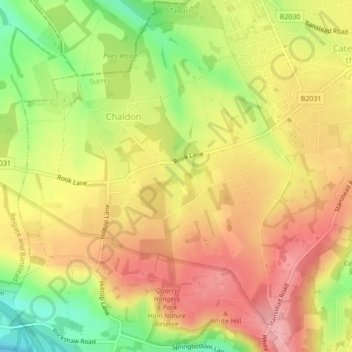
Name: Topografische Karte Chaldon, Höhe, Relief.
Ort: Chaldon, Tandridge, Surrey, England, United Kingdom (51.26730 -0.13152 51.29085 -0.08971)
Durchschnittliche Höhe: 181 m
Minimale Höhe: 109 m
Maximale Höhe: 233 m
Andere topografische Karten
Klicken Sie auf eine Karte, um ihre Topografie, ihre Höhe und ihr Relief anzuzeigen.
Caterham
United Kingdom > England > Surrey > Tandridge
In 1840 Caterham contained a total of 477 residents (figures taken from that census, compiled in an 1848 topographical encyclopedia) and in 1848 468 acres (189 ha) of its 2,386 acres (966 ha) were common land. Similar to today, 175 acres (71 ha) mostly steeper acres were woodland.
Durchschnittliche Höhe: 157 m
Botley Hill
United Kingdom > England > Surrey > Tandridge
Botley Hill is a Marilyn (a hill with topographic prominence of at least 150m), and the third highest point in the county (after the peaks of Leith Hill south of Dorking and Gibbet Hill in Hindhead, both on the Greensand Ridge).
Durchschnittliche Höhe: 206 m
Caterham
United Kingdom > England > Surrey > Tandridge
In 1840 Caterham contained a total of 477 residents (figures taken from that census, compiled in an 1848 topographical encyclopedia) and in 1848 468 acres (189 ha) of its 2,386 acres (966 ha) were common land. Similar to today, 175 acres (71 ha) mostly steeper acres were woodland.
Durchschnittliche Höhe: 157 m