
Spenden
Rüste dich für dein nächstes Abenteuer:
Als Amazon-Partner verdient diese Website an qualifizierten Käufen, ohne zusätzliche Kosten für Sie.
Topografische Karte Middle Fork Payette River
Klicken Sie auf die Karte, um die Höhe anzuzeigen.
Spenden
Rüste dich für dein nächstes Abenteuer:
Als Amazon-Partner verdient diese Website an qualifizierten Käufen, ohne zusätzliche Kosten für Sie.
Über diese Karte
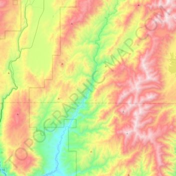
Name: Topografische Karte Middle Fork Payette River, Höhe, Relief.
Durchschnittliche Höhe: 1.663 m
Minimale Höhe: 919 m
Maximale Höhe: 2.522 m
Spenden
Rüste dich für dein nächstes Abenteuer:
Als Amazon-Partner verdient diese Website an qualifizierten Käufen, ohne zusätzliche Kosten für Sie.
Andere topografische Karten
Klicken Sie auf eine Karte, um ihre Topografie, ihre Höhe und ihr Relief anzuzeigen.
Boise
United States > Idaho > Ada County
Boise (locally /ˈbɔɪsi/ BOY-see) is the capital and most populous city of the U.S. state of Idaho and is the county seat of Ada County. As of the 2020 census, there were 235,684 people residing in the city. On the Boise River in southwestern Idaho, it is 41 miles (66 km) east of the Oregon border and 110…
Durchschnittliche Höhe: 1.040 m
Kamiah
United States > Idaho > Lewis County
The city is located at the confluence of Lawyer Creek and the Clearwater River on the left bank of the latter. In the Kamiah area, the Lewis-Idaho County line follows Lawyer Creek to its confluence with the Clearwater, and then turns to follow the Clearwater. U.S. Route 12 passes through Kamiah, crossing from…
Durchschnittliche Höhe: 399 m
Spenden
Rüste dich für dein nächstes Abenteuer:
Als Amazon-Partner verdient diese Website an qualifizierten Käufen, ohne zusätzliche Kosten für Sie.
Spenden
Rüste dich für dein nächstes Abenteuer:
Als Amazon-Partner verdient diese Website an qualifizierten Käufen, ohne zusätzliche Kosten für Sie.
Idaho Panhandle National Forests
Elevations on the IPNF range from 2,100 to 7,600 feet with as much as 80 inches of precipitation at high elevations. The IPNF is characterized by several mountain ranges including the Selkirk Mountains, Cabinet Mountains, Purcell Mountains, Coeur d'Alene Mountains, and Bitterroot Range, interspersed with large…
Durchschnittliche Höhe: 1.122 m
Spenden
Rüste dich für dein nächstes Abenteuer:
Als Amazon-Partner verdient diese Website an qualifizierten Käufen, ohne zusätzliche Kosten für Sie.
Lake Coeur d'Alene
United States > Idaho > Kootenai County > Harrison
The lake's elevation varies from 2,128 feet (649 m) above sea level in the summer to up to 7 feet (2.1 m) lower in the winter, controlled by the Post Falls Dam 9 miles (14 km) below the lake on the Spokane River.
Durchschnittliche Höhe: 827 m
Emmett
United States > Idaho > Gem County
According to the United States Census Bureau, the city has a total area of 2.82 square miles (7.30 km2), of which 2.80 square miles (7.25 km2) is land and 0.02 square miles (0.05 km2) is water. It is located south of the Payette River, at an elevation of 2,362 feet (720 m) above sea level.
Durchschnittliche Höhe: 738 m
Winchester
United States > Idaho > Lewis County
Winchester is located at 46°14′27″N 116°37′24″W / 46.24083°N 116.62333°W / 46.24083; -116.62333 , at an elevation of 3,980 feet (1,210 m) above sea level.
Durchschnittliche Höhe: 1.214 m
Spenden
Rüste dich für dein nächstes Abenteuer:
Als Amazon-Partner verdient diese Website an qualifizierten Käufen, ohne zusätzliche Kosten für Sie.
Spenden
Rüste dich für dein nächstes Abenteuer:
Als Amazon-Partner verdient diese Website an qualifizierten Käufen, ohne zusätzliche Kosten für Sie.
Spenden
Rüste dich für dein nächstes Abenteuer:
Als Amazon-Partner verdient diese Website an qualifizierten Käufen, ohne zusätzliche Kosten für Sie.
Fairfield
United States > Idaho > Camas County
Fairfield is located at City 43°20′46″N 114°47′28″W / 43.34611°N 114.79111°W / 43.34611; -114.79111 (43.346000, -114.791159), at an elevation of 5,066 feet (1,544 m) above sea level.
Durchschnittliche Höhe: 1.546 m
American Falls
United States > Idaho > Power County
American Falls is located at 42°46′52″N 112°51′20″W / 42.78111°N 112.85556°W / 42.78111; -112.85556 (42.781121, -112.855694), at an elevation of 4,406 feet (1,343 m).
Durchschnittliche Höhe: 1.346 m
Spenden
Rüste dich für dein nächstes Abenteuer:
Als Amazon-Partner verdient diese Website an qualifizierten Käufen, ohne zusätzliche Kosten für Sie.
Aberdeen
United States > Idaho > Bingham County
Aberdeen is located at 42°56′36″N 112°50′22″W / 42.94333°N 112.83944°W / 42.94333; -112.83944 (42.943405, -112.839322), at an elevation of 4,403 feet (1,342 m) above sea level. According to the United States Census Bureau, the city has a total area of 1.03 square miles (2.67 km2), all of it land.
Durchschnittliche Höhe: 1.341 m
Spenden
Rüste dich für dein nächstes Abenteuer:
Als Amazon-Partner verdient diese Website an qualifizierten Käufen, ohne zusätzliche Kosten für Sie.
Spenden
Rüste dich für dein nächstes Abenteuer:
Als Amazon-Partner verdient diese Website an qualifizierten Käufen, ohne zusätzliche Kosten für Sie.
Spenden
Rüste dich für dein nächstes Abenteuer:
Als Amazon-Partner verdient diese Website an qualifizierten Käufen, ohne zusätzliche Kosten für Sie.
Ferdinand
United States > Idaho > Idaho County
Ferdinand is located at 46°9′10″N 116°23′26″W / 46.15278°N 116.39056°W / 46.15278; -116.39056 (46.152701, -116.390438), at an elevation of 3,720 feet (1,130 m) above sea level on the Camas Prairie.
Durchschnittliche Höhe: 1.148 m
Spenden
Rüste dich für dein nächstes Abenteuer:
Als Amazon-Partner verdient diese Website an qualifizierten Käufen, ohne zusätzliche Kosten für Sie.
Spenden
Rüste dich für dein nächstes Abenteuer:
Als Amazon-Partner verdient diese Website an qualifizierten Käufen, ohne zusätzliche Kosten für Sie.
Spenden
Rüste dich für dein nächstes Abenteuer:
Als Amazon-Partner verdient diese Website an qualifizierten Käufen, ohne zusätzliche Kosten für Sie.
Clayton
United States > Idaho > Custer County
Clayton is located at 44°15′32″N 114°23′59″W / 44.25889°N 114.39972°W / 44.25889; -114.39972 (44.259014, -114.399725), at an elevation of 5,489 feet (1,673 m) above sea level.
Durchschnittliche Höhe: 1.965 m
Spenden
Rüste dich für dein nächstes Abenteuer:
Als Amazon-Partner verdient diese Website an qualifizierten Käufen, ohne zusätzliche Kosten für Sie.
Spenden
Rüste dich für dein nächstes Abenteuer:
Als Amazon-Partner verdient diese Website an qualifizierten Käufen, ohne zusätzliche Kosten für Sie.
Reubens
United States > Idaho > Lewis County
Reubens is located at 46°19′25″N 116°32′31″W / 46.32361°N 116.54194°W / 46.32361; -116.54194, at an elevation of 3,527 feet (1,075 m) above sea level.
Durchschnittliche Höhe: 1.077 m
Tensed
United States > Idaho > Benewah County
Tensed is located at 47°9′37″N 116°55′27″W / 47.16028°N 116.92417°W / 47.16028; -116.92417 (47.160284, -116.924304), at an elevation of 2,562 feet (781 m) above sea level.
Durchschnittliche Höhe: 785 m
Spenden
Rüste dich für dein nächstes Abenteuer:
Als Amazon-Partner verdient diese Website an qualifizierten Käufen, ohne zusätzliche Kosten für Sie.
Onaway
United States > Idaho > Latah County
Onaway is located at 46°55′43″N 116°53′21″W / 46.92861°N 116.88917°W / 46.92861; -116.88917 (46.928565, -116.889074), at an elevation of 2,621 feet (799 m) above sea level. According to the United States Census Bureau, the city has a total area of 0.15 square miles (0.39 km2), all of it land.
Durchschnittliche Höhe: 794 m
Spenden
Rüste dich für dein nächstes Abenteuer:
Als Amazon-Partner verdient diese Website an qualifizierten Käufen, ohne zusätzliche Kosten für Sie.
Oldtown
United States > Idaho > Bonner County
Oldtown is located at 48°11′8″N 117°1′49″W / 48.18556°N 117.03028°W / 48.18556; -117.03028 (48.185623, -117.030158), at an elevation of 2,134 feet (650 meters).
Durchschnittliche Höhe: 682 m
Spenden
Rüste dich für dein nächstes Abenteuer:
Als Amazon-Partner verdient diese Website an qualifizierten Käufen, ohne zusätzliche Kosten für Sie.
Bancroft
United States > Idaho > Caribou County
Bancroft is located at 42°43′10″N 111°53′10″W / 42.71944°N 111.88611°W / 42.71944; -111.88611 (42.719440, -111.886194), at an elevation of 5,420 feet (1,650 m).
Durchschnittliche Höhe: 1.658 m
Spenden
Rüste dich für dein nächstes Abenteuer:
Als Amazon-Partner verdient diese Website an qualifizierten Käufen, ohne zusätzliche Kosten für Sie.
Declo
United States > Idaho > Cassia County
Declo is located at 42°31′10″N 113°37′48″W / 42.51944°N 113.63000°W / 42.51944; -113.63000 (42.519441, -113.629978), at an elevation of 4,219 feet (1,286 m) above sea level. According to the United States Census Bureau, the city has a total area of 0.28 square miles (0.73 km2), all of it land.
Durchschnittliche Höhe: 1.284 m
Newdale
United States > Idaho > Fremont County
Newdale is the nearest city to the Teton Dam, which failed on June 5, 1976. Newdale did not receive any flooding or damage, due to its elevation and position relative to the dam.
Durchschnittliche Höhe: 1.550 m
Spenden
Rüste dich für dein nächstes Abenteuer:
Als Amazon-Partner verdient diese Website an qualifizierten Käufen, ohne zusätzliche Kosten für Sie.
Clifton
United States > Idaho > Franklin County
Clifton is located at 42°11′15″N 112°0′21″W / 42.18750°N 112.00583°W / 42.18750; -112.00583 (42.187585, -112.005856), at 4,860 feet (1,480 m) in elevation.
Durchschnittliche Höhe: 1.494 m
Spenden
Rüste dich für dein nächstes Abenteuer:
Als Amazon-Partner verdient diese Website an qualifizierten Käufen, ohne zusätzliche Kosten für Sie.
Spenden
Rüste dich für dein nächstes Abenteuer:
Als Amazon-Partner verdient diese Website an qualifizierten Käufen, ohne zusätzliche Kosten für Sie.
Smelterville
United States > Idaho > Shoshone County
Smelterville is located at 47°32′34″N 116°10′45″W / 47.54278°N 116.17917°W / 47.54278; -116.17917 (47.542690, -116.179281), at an elevation of 2,234 feet (681 m) above sea level.
Durchschnittliche Höhe: 742 m
Spenden
Rüste dich für dein nächstes Abenteuer:
Als Amazon-Partner verdient diese Website an qualifizierten Käufen, ohne zusätzliche Kosten für Sie.
Arco
United States > Idaho > Butte County
Arco Peak, located two mile north of the community at an elevation of 7547 feet, rises 2220 feet above the city.
Durchschnittliche Höhe: 1.634 m
Spenden
Rüste dich für dein nächstes Abenteuer:
Als Amazon-Partner verdient diese Website an qualifizierten Käufen, ohne zusätzliche Kosten für Sie.
Genesee
United States > Idaho > Latah County
Genesee is located at 46°33.0′N 116°55.5′W / 46.5500°N 116.9250°W / 46.5500; -116.9250 (46.5506, -116.9245)., at an elevation of 2,680 feet (817 m) above sea level. Located in the Palouse region, it is approximately 14 miles (23 km) south of Moscow, about halfway to Lewiston. The city center…
Durchschnittliche Höhe: 824 m
Spenden
Rüste dich für dein nächstes Abenteuer:
Als Amazon-Partner verdient diese Website an qualifizierten Käufen, ohne zusätzliche Kosten für Sie.