
Topografische Karte Buford
Interaktive Karte
Klicken Sie auf die Karte, um die Höhe anzuzeigen.
Über diese Karte
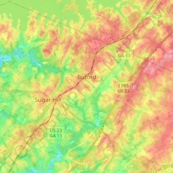
Name: Topografische Karte Buford, Höhe, Relief.
Ort: Buford, Gwinnett County, Georgia, United States (34.06061 -84.04827 34.16851 -83.93922)
Durchschnittliche Höhe: 340 m
Minimale Höhe: 285 m
Maximale Höhe: 393 m
Buford is located in both northern Gwinnett County in northern Georgia, with a small portion extending north into Hall County. The city is a suburb within the Atlanta metropolitan area. According to the United States Census Bureau, as of 2010 the city has a total land area of 17.09 square miles (44.26 km2), of which 17.01 square miles (44.06 km2) is land and 0.08 square miles (0.20 km2), or 0.44%, is water. The city's elevation is 1,183 feet (361 m).
Andere topografische Karten
Klicken Sie auf eine Karte, um ihre Topografie, ihre Höhe und ihr Relief anzuzeigen.
Suwanee
United States > Georgia > Gwinnett County
Suwanee, Gwinnett County, Georgia, United States
Durchschnittliche Höhe: 311 m
Rest Haven
United States > Georgia > Gwinnett County
Rest Haven, Gwinnett County, Georgia, United States
Durchschnittliche Höhe: 349 m
Berkeley Lake
United States > Georgia > Gwinnett County
Berkeley Lake, Gwinnett County, Georgia, United States
Durchschnittliche Höhe: 311 m
Mountain Park
United States > Georgia > Gwinnett County
Mountain Park, Gwinnett County, Georgia, 30047, United States
Durchschnittliche Höhe: 292 m
Lawrenceville
United States > Georgia > Gwinnett County
Lawrenceville, Gwinnett County, Georgia, United States
Durchschnittliche Höhe: 312 m
Myrdell Estates
United States > Georgia > Gwinnett County
Myrdell Estates, Gwinnett County, Georgia, 30519, United States
Durchschnittliche Höhe: 355 m
Oak Village
United States > Georgia > Gwinnett County
Oak Village, Gwinnett County, Georgia, 30043, United States
Durchschnittliche Höhe: 316 m
Lilburn
United States > Georgia > Gwinnett County
Lilburn, Gwinnett County, Georgia, United States
Durchschnittliche Höhe: 291 m
Duluth
United States > Georgia > Gwinnett County
Duluth, Gwinnett County, Georgia, United States
Durchschnittliche Höhe: 305 m
Sugar Hill
United States > Georgia > Gwinnett County
Sugar Hill, Gwinnett County, Georgia, United States
Durchschnittliche Höhe: 332 m
Peachtree Corners
United States > Georgia > Gwinnett County
Peachtree Corners, Gwinnett County, Georgia, 30092, United States
Durchschnittliche Höhe: 303 m
Grayson
United States > Georgia > Gwinnett County
Grayson, Gwinnett County, Georgia, United States
Durchschnittliche Höhe: 319 m
Berry Lake
United States > Georgia > Gwinnett County > Suwanee
Berry Lake, Suwanee, Gwinnett County, Georgia, United States
Durchschnittliche Höhe: 304 m
Harbins Park
United States > Georgia > Gwinnett County
Harbins Park, Gwinnett County, Georgia, 30045-6560, United States
Durchschnittliche Höhe: 271 m
Settles Bridge
United States > Georgia > Gwinnett County > Suwanee > Settles Bridge
Settles Bridge, Suwanee, Gwinnett County, Georgia, 30024, United States
Durchschnittliche Höhe: 314 m
Duluth
United States > Georgia > Gwinnett County > Duluth
Duluth, Gwinnett County, Georgia, 30096, United States
Durchschnittliche Höhe: 304 m
Dacula
United States > Georgia > Gwinnett County
Dacula, Gwinnett County, Georgia, United States
Durchschnittliche Höhe: 313 m
Rock Creek Estates
United States > Georgia > Gwinnett County > Buford > Rock Creek Estates
Rock Creek Estates, Buford, Gwinnett County, Georgia, 30519, United States
Durchschnittliche Höhe: 338 m
Snellville
United States > Georgia > Gwinnett County
Snellville, Gwinnett County, Georgia, United States
Durchschnittliche Höhe: 300 m
Norcross
United States > Georgia > Gwinnett County
Norcross, Gwinnett County, Georgia, 30071, United States
Durchschnittliche Höhe: 309 m