
Topografische Karte Harrower Glacier
Interaktive Karte
Klicken Sie auf die Karte, um die Höhe anzuzeigen.
Über diese Karte
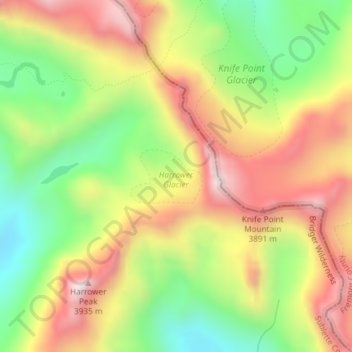
Name: Topografische Karte Harrower Glacier, Höhe, Relief.
Durchschnittliche Höhe: 3.637 m
Minimale Höhe: 3.314 m
Maximale Höhe: 3.969 m
Andere topografische Karten
Klicken Sie auf eine Karte, um ihre Topografie, ihre Höhe und ihr Relief anzuzeigen.
Downs Glacier
Downs Glacier, Fremont County, Wyoming, USA
Durchschnittliche Höhe: 3.727 m
Washakie Glacier
Washakie Glacier, Waskakie Pass Trail, Fremont County, Wyoming, USA
Durchschnittliche Höhe: 3.399 m
Cirque of the Towers
Cirque of the Towers, Fremont County, Wyoming, USA
Durchschnittliche Höhe: 3.347 m
Grand Teton National Park
Grand Teton National Park, Teton Park Road, Teton County, Wyoming, 83013, USA
Durchschnittliche Höhe: 2.409 m
Falling Ice Glacier
Falling Ice Glacier, Paintbrush Canyon, Teton County, Wyoming, USA
Durchschnittliche Höhe: 2.988 m
Tiny Glacier
Tiny Glacier, Cook Lake Loop, Sublette County, Wyoming, USA
Durchschnittliche Höhe: 3.539 m
Middle Teton Glacier
USA > Wyoming > Beaver Creek
Middle Teton Glacier, Garnet Canyon Trail, Beaver Creek, Teton County, Wyoming, USA
Durchschnittliche Höhe: 3.383 m
Fishhawk Glacier
Fishhawk Glacier, Park County, Wyoming, USA
Durchschnittliche Höhe: 3.218 m
Helen Glacier
Helen Glacier, Titcomb Basin Trail, Sublette County, Wyoming, USA
Durchschnittliche Höhe: 3.702 m
Gooseneck Glacier
Gooseneck Glacier, Glacier Trail, Fremont County, Wyoming, USA
Durchschnittliche Höhe: 3.701 m
Twins Glacier
Twins Glacier, Titcomb Basin Trail, Sublette County, Wyoming, USA
Durchschnittliche Höhe: 3.599 m
Mammoth Glacier
Mammoth Glacier, Glacier Trail, Sublette County, Wyoming, USA
Durchschnittliche Höhe: 3.683 m
Bull Lake Glacier
Bull Lake Glacier, Indain Pass Trail, Sublette County, Wyoming, USA
Durchschnittliche Höhe: 3.643 m
Teepe Glacier
USA > Wyoming > Beaver Creek
Teepe Glacier, Garnet Canyon Trail, Beaver Creek, Teton County, Wyoming, USA
Durchschnittliche Höhe: 3.338 m
Dinwoody Glacier
Dinwoody Glacier, Glacier Trail, Fremont County, Wyoming, USA
Durchschnittliche Höhe: 3.688 m
Connie Glacier
Connie Glacier, Sublette County, Wyoming, USA
Durchschnittliche Höhe: 3.693 m
Skillet Glacier
Skillet Glacier, Trapper Lake Trail, Teton County, Wyoming, USA
Durchschnittliche Höhe: 2.959 m
Hooker Glacier
Hooker Glacier, Baptiste Lake, Fremont County, Wyoming, USA
Durchschnittliche Höhe: 3.420 m
Mount Woodrow Wilson
Mount Woodrow Wilson, Sublette County, Wyoming, USA
Durchschnittliche Höhe: 3.710 m
Continental Glacier
Continental Glacier, Fremont County, Wyoming, USA
Durchschnittliche Höhe: 3.768 m
Black Tooth Mountain
Black Tooth Mountain, Johnson County, Wyoming, USA
Durchschnittliche Höhe: 3.511 m
Wind River Peak
Wind River Peak, Fremont County, Wyoming, USA
Durchschnittliche Höhe: 3.632 m
Mount Whitecap
Mount Whitecap, Sublette County, Wyoming, USA
Durchschnittliche Höhe: 3.528 m
Lower Fremont Glacier
Lower Fremont Glacier, Indain Pass Trail, Sublette County, Wyoming, USA
Durchschnittliche Höhe: 3.706 m
DuNoir Glacier
DuNoir Glacier, East Dunoir Trail, Fremont County, Wyoming, USA
Durchschnittliche Höhe: 3.236 m
Sacagawea Glacier
Sacagawea Glacier, Titcomb Basin Trail, Sublette County, Wyoming, USA
Durchschnittliche Höhe: 3.756 m
Klondike Lake
Klondike Lake, Glacier Trail, Fremont County, Wyoming, USA
Durchschnittliche Höhe: 3.579 m
Heap Steep Glacier
Heap Steep Glacier, Glacier Trail, Fremont County, Wyoming, USA
Durchschnittliche Höhe: 3.698 m