
Topografische Karte Otis
Interaktive Karte
Klicken Sie auf die Karte, um die Höhe anzuzeigen.
Über diese Karte
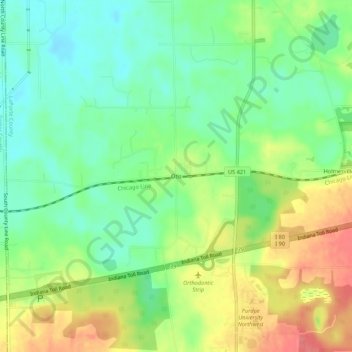
Name: Topografische Karte Otis, Höhe, Relief.
Ort: Otis, LaPorte County, Indiana, 46391, United States (41.57921 -86.92586 41.61921 -86.88586)
Durchschnittliche Höhe: 228 m
Minimale Höhe: 200 m
Maximale Höhe: 268 m
Andere topografische Karten
Klicken Sie auf eine Karte, um ihre Topografie, ihre Höhe und ihr Relief anzuzeigen.
Springville
United States > Indiana > LaPorte County
Springville, LaPorte County, Indiana, United States
Durchschnittliche Höhe: 229 m
Fish Creek
United States > Indiana > LaPorte County > Fish Lake
Fish Creek, Fish Lake, LaPorte County, Indiana, United States
Durchschnittliche Höhe: 217 m
Wanatah
United States > Indiana > LaPorte County
Wanatah, LaPorte County, Indiana, 46390, United States
Durchschnittliche Höhe: 223 m
Michigan City
United States > Indiana > LaPorte County
Michigan City, LaPorte County, Indiana, United States
Durchschnittliche Höhe: 188 m