
Spenden
Rüste dich für dein nächstes Abenteuer:
Als Amazon-Partner verdient diese Website an qualifizierten Käufen, ohne zusätzliche Kosten für Sie.
Topografische Karte Britwell Salome
Klicken Sie auf die Karte, um die Höhe anzuzeigen.
Spenden
Rüste dich für dein nächstes Abenteuer:
Als Amazon-Partner verdient diese Website an qualifizierten Käufen, ohne zusätzliche Kosten für Sie.
Über diese Karte
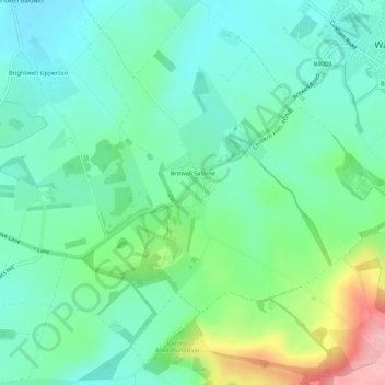
Name: Topografische Karte Britwell Salome, Höhe, Relief.
Durchschnittliche Höhe: 123 m
Minimale Höhe: 82 m
Maximale Höhe: 232 m
Spenden
Rüste dich für dein nächstes Abenteuer:
Als Amazon-Partner verdient diese Website an qualifizierten Käufen, ohne zusätzliche Kosten für Sie.
Andere topografische Karten
Klicken Sie auf eine Karte, um ihre Topografie, ihre Höhe und ihr Relief anzuzeigen.
Henley-on-Thames
United Kingdom > England > Oxfordshire > South Oxfordshire
Durchschnittliche Höhe: 78 m
Middle Assendon
United Kingdom > England > Oxfordshire > South Oxfordshire
Durchschnittliche Höhe: 109 m
Harpsden Wood
United Kingdom > England > Oxfordshire > South Oxfordshire > Henley-on-Thames > Harpsden
Durchschnittliche Höhe: 63 m
Spenden
Rüste dich für dein nächstes Abenteuer:
Als Amazon-Partner verdient diese Website an qualifizierten Käufen, ohne zusätzliche Kosten für Sie.
Kingwood Common
United Kingdom > England > Oxfordshire > South Oxfordshire > Highmoor
Durchschnittliche Höhe: 125 m
Waterperry
United Kingdom > England > Oxfordshire > South Oxfordshire > Waterstock
Durchschnittliche Höhe: 63 m
Spenden
Rüste dich für dein nächstes Abenteuer:
Als Amazon-Partner verdient diese Website an qualifizierten Käufen, ohne zusätzliche Kosten für Sie.
Cane End
United Kingdom > England > Oxfordshire > South Oxfordshire > Gallowstree Common
Durchschnittliche Höhe: 108 m
Cowleaze Wood
United Kingdom > England > Oxfordshire > South Oxfordshire > Lewknor
Durchschnittliche Höhe: 209 m
Wittenham Clumps
United Kingdom > England > Oxfordshire > South Oxfordshire > Little Wittenham
Durchschnittliche Höhe: 65 m
Spenden
Rüste dich für dein nächstes Abenteuer:
Als Amazon-Partner verdient diese Website an qualifizierten Käufen, ohne zusätzliche Kosten für Sie.
Mongewell
United Kingdom > England > Oxfordshire > South Oxfordshire > Crowmarsh Gifford
Durchschnittliche Höhe: 59 m
Sonning Eye
United Kingdom > England > Oxfordshire > South Oxfordshire > Dunsden Green > Sonning Eye
Durchschnittliche Höhe: 44 m
Whitchurch Hill
United Kingdom > England > Oxfordshire > South Oxfordshire
Durchschnittliche Höhe: 111 m
Preston Crowmarsh
United Kingdom > England > Oxfordshire > South Oxfordshire > Benson
Durchschnittliche Höhe: 58 m
Spenden
Rüste dich für dein nächstes Abenteuer:
Als Amazon-Partner verdient diese Website an qualifizierten Käufen, ohne zusätzliche Kosten für Sie.
Ewelme Park
United Kingdom > England > Oxfordshire > South Oxfordshire > Swyncombe
Durchschnittliche Höhe: 172 m
Chalkhouse Green
United Kingdom > England > Oxfordshire > South Oxfordshire > Kidmore End
Durchschnittliche Höhe: 83 m
Spenden
Rüste dich für dein nächstes Abenteuer:
Als Amazon-Partner verdient diese Website an qualifizierten Käufen, ohne zusätzliche Kosten für Sie.
Draycot
United Kingdom > England > Oxfordshire > South Oxfordshire > Tiddington
Durchschnittliche Höhe: 68 m
Pill Pond
United Kingdom > England > Oxfordshire > South Oxfordshire > Didcot
Durchschnittliche Höhe: 71 m
Wet n Wild Oxford
United Kingdom > England > Oxfordshire > South Oxfordshire > Berinsfield
Durchschnittliche Höhe: 51 m
Gatehampton
United Kingdom > England > Oxfordshire > South Oxfordshire > Goring-on-Thames
Durchschnittliche Höhe: 88 m
Spenden
Rüste dich für dein nächstes Abenteuer:
Als Amazon-Partner verdient diese Website an qualifizierten Käufen, ohne zusätzliche Kosten für Sie.
Baldon Row
United Kingdom > England > Oxfordshire > South Oxfordshire > Toot Baldon
Durchschnittliche Höhe: 73 m
Little Haseley
United Kingdom > England > Oxfordshire > South Oxfordshire > Great Haseley
Durchschnittliche Höhe: 73 m
Newnham Murren
United Kingdom > England > Oxfordshire > South Oxfordshire > Crowmarsh Gifford
Durchschnittliche Höhe: 59 m
Spenden
Rüste dich für dein nächstes Abenteuer:
Als Amazon-Partner verdient diese Website an qualifizierten Käufen, ohne zusätzliche Kosten für Sie.
Christmas Common
United Kingdom > England > Oxfordshire > South Oxfordshire > Watlington
Christmas Common is a hamlet in Watlington civil parish, Oxfordshire about 7+1⁄2 miles (12 km) south of Thame in Oxfordshire, close to the boundary with Buckinghamshire. The hamlet is 812 feet (247 m) above sea level on an escarpment of the Chiltern Hills. Because of its elevation, Christmas Common has two…
Durchschnittliche Höhe: 192 m
Spenden
Rüste dich für dein nächstes Abenteuer:
Als Amazon-Partner verdient diese Website an qualifizierten Käufen, ohne zusätzliche Kosten für Sie.
Chinnor Quarry 2B
United Kingdom > England > Oxfordshire > South Oxfordshire > Kingston Blount > Crowell
Durchschnittliche Höhe: 163 m
Kingston Blount
United Kingdom > England > Oxfordshire > South Oxfordshire
Durchschnittliche Höhe: 137 m
Crowmarsh Gifford
United Kingdom > England > Oxfordshire > South Oxfordshire
Durchschnittliche Höhe: 61 m
Kingston Stert
United Kingdom > England > Oxfordshire > South Oxfordshire > Aston Rowant
Durchschnittliche Höhe: 96 m
Spenden
Rüste dich für dein nächstes Abenteuer:
Als Amazon-Partner verdient diese Website an qualifizierten Käufen, ohne zusätzliche Kosten für Sie.
Woodperry
United Kingdom > England > Oxfordshire > South Oxfordshire > Stanton St John
Durchschnittliche Höhe: 89 m
Edmonds Park
United Kingdom > England > Oxfordshire > South Oxfordshire > Didcot > East Hagbourne
Durchschnittliche Höhe: 68 m
Overy
United Kingdom > England > Oxfordshire > South Oxfordshire > Dorchester-on-Thames
Durchschnittliche Höhe: 55 m
Spenden
Rüste dich für dein nächstes Abenteuer:
Als Amazon-Partner verdient diese Website an qualifizierten Käufen, ohne zusätzliche Kosten für Sie.
Lower Shiplake
United Kingdom > England > Oxfordshire > South Oxfordshire
Durchschnittliche Höhe: 56 m
Dorchester-on-Thames
United Kingdom > England > Oxfordshire > South Oxfordshire
Durchschnittliche Höhe: 54 m
Witheridge Hill
United Kingdom > England > Oxfordshire > South Oxfordshire > Highmoor > Witheridge Hill
Durchschnittliche Höhe: 144 m
Brookhampton
United Kingdom > England > Oxfordshire > South Oxfordshire > Chiselhampton > Brookhampton
Durchschnittliche Höhe: 59 m
Spenden
Rüste dich für dein nächstes Abenteuer:
Als Amazon-Partner verdient diese Website an qualifizierten Käufen, ohne zusätzliche Kosten für Sie.
Path Hill
United Kingdom > England > Oxfordshire > South Oxfordshire > Whitchurch Hill
Durchschnittliche Höhe: 99 m
Burcot
United Kingdom > England > Oxfordshire > South Oxfordshire > Clifton Hampden
Durchschnittliche Höhe: 59 m
Henley-on-Thames
United Kingdom > England > Oxfordshire > South Oxfordshire
Durchschnittliche Höhe: 78 m
Henley-on-Thames
United Kingdom > England > Oxfordshire > South Oxfordshire
Durchschnittliche Höhe: 78 m
Spenden
Rüste dich für dein nächstes Abenteuer:
Als Amazon-Partner verdient diese Website an qualifizierten Käufen, ohne zusätzliche Kosten für Sie.
Peppard Common
United Kingdom > England > Oxfordshire > South Oxfordshire > Rotherfield Peppard
Durchschnittliche Höhe: 108 m
Dorchester-on-Thames
United Kingdom > England > Oxfordshire > South Oxfordshire
Durchschnittliche Höhe: 54 m