
Topografische Karte Thurcaston
Interaktive Karte
Klicken Sie auf die Karte, um die Höhe anzuzeigen.
Über diese Karte
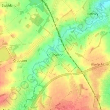
Name: Topografische Karte Thurcaston, Höhe, Relief.
Durchschnittliche Höhe: 73 m
Minimale Höhe: 45 m
Maximale Höhe: 97 m
Andere topografische Karten
Klicken Sie auf eine Karte, um ihre Topografie, ihre Höhe und ihr Relief anzuzeigen.
Barkby Thorpe
United Kingdom > England > Leicestershire > Borough of Charnwood
Barkby Thorpe, Borough of Charnwood, Leicestershire, England, United Kingdom
Durchschnittliche Höhe: 89 m
Mammoth Lake
United Kingdom > England > Leicestershire > Borough of Charnwood > Thurmaston
Mammoth Lake, Thurmaston, Borough of Charnwood, Leicestershire, England, United Kingdom
Durchschnittliche Höhe: 58 m
Charnwood Forest Canal (Disused)
United Kingdom > England > Leicestershire > Borough of Charnwood > Nanpantan
Charnwood Forest Canal (Disused), Nanpantan, Borough of Charnwood, Leicestershire, England, LE11 3YA, United Kingdom
Durchschnittliche Höhe: 98 m
Anstey
United Kingdom > England > Leicestershire > Borough of Charnwood
Anstey, Borough of Charnwood, Leicestershire, England, United Kingdom
Durchschnittliche Höhe: 84 m
Wanlip
United Kingdom > England > Leicestershire > Borough of Charnwood
Wanlip, Borough of Charnwood, Leicestershire, England, LE7 4PH, United Kingdom
Durchschnittliche Höhe: 61 m
Ratcliffe on the Wreake
United Kingdom > England > Leicestershire > Borough of Charnwood
Ratcliffe on the Wreake, Borough of Charnwood, Leicestershire, England, LE7 4SN, United Kingdom
Durchschnittliche Höhe: 68 m
Seagrave
United Kingdom > England > Leicestershire > Borough of Charnwood
Seagrave, Borough of Charnwood, Leicestershire, England, LE12 7NL, United Kingdom
Durchschnittliche Höhe: 92 m