
Topografische Karte Pleasant Plains
Interaktive Karte
Klicken Sie auf die Karte, um die Höhe anzuzeigen.
Über diese Karte
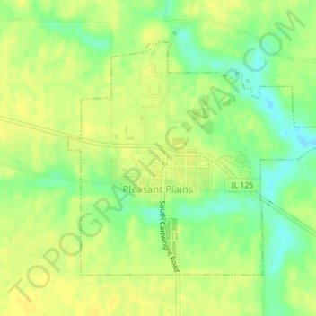
Name: Topografische Karte Pleasant Plains, Höhe, Relief.
Ort: Pleasant Plains, Sangamon County, Illinois, United States (39.86548 -89.93121 39.88543 -89.90122)
Durchschnittliche Höhe: 187 m
Minimale Höhe: 173 m
Maximale Höhe: 193 m
Andere topografische Karten
Klicken Sie auf eine Karte, um ihre Topografie, ihre Höhe und ihr Relief anzuzeigen.
Springfield
United States > Illinois > Sangamon County
Springfield, Sangamon County, Illinois, United States
Durchschnittliche Höhe: 178 m
Williamsville
United States > Illinois > Sangamon County
Williamsville, Sangamon County, Illinois, 62693, United States
Durchschnittliche Höhe: 177 m
Archer
United States > Illinois > Sangamon County > Springfield
Archer, Springfield, Sangamon County, Illinois, 62711, United States
Durchschnittliche Höhe: 184 m
Spaulding
United States > Illinois > Sangamon County
Spaulding, Sangamon County, Illinois, United States
Durchschnittliche Höhe: 171 m