
Spenden
Rüste dich für dein nächstes Abenteuer:
Als Amazon-Partner verdient diese Website an qualifizierten Käufen, ohne zusätzliche Kosten für Sie.
Topografische Karte Kaibab
Klicken Sie auf die Karte, um die Höhe anzuzeigen.
Spenden
Rüste dich für dein nächstes Abenteuer:
Als Amazon-Partner verdient diese Website an qualifizierten Käufen, ohne zusätzliche Kosten für Sie.
Über diese Karte
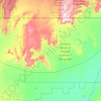
Name: Topografische Karte Kaibab, Höhe, Relief.
Ort: Kaibab, Mohave County, Arizona, United States (36.83033 -112.82950 37.00082 -112.49968)
Durchschnittliche Höhe: 1.600 m
Minimale Höhe: 1.304 m
Maximale Höhe: 2.150 m
Spenden
Rüste dich für dein nächstes Abenteuer:
Als Amazon-Partner verdient diese Website an qualifizierten Käufen, ohne zusätzliche Kosten für Sie.
Andere topografische Karten
Klicken Sie auf eine Karte, um ihre Topografie, ihre Höhe und ihr Relief anzuzeigen.
Bullhead City
United States > Arizona > Mohave County > Bullhead City > Bullhead City
Durchschnittliche Höhe: 245 m
Spenden
Rüste dich für dein nächstes Abenteuer:
Als Amazon-Partner verdient diese Website an qualifizierten Käufen, ohne zusätzliche Kosten für Sie.
Spenden
Rüste dich für dein nächstes Abenteuer:
Als Amazon-Partner verdient diese Website an qualifizierten Käufen, ohne zusätzliche Kosten für Sie.
Littlefield
United States > Arizona > Mohave County > Beaver Dam > Littlefield
Durchschnittliche Höhe: 588 m
Kingman
United States > Arizona > Mohave County
Lt. Edward Fitzgerald Beale, a U.S. Navy officer in the service of the Army Corps of Topographical Engineers, was ordered by the U.S. War Department to build a federal wagon road across the 35th parallel. His secondary orders were to test the feasibility of the use of camels as pack animals in the Southwestern…
Durchschnittliche Höhe: 1.131 m
Spenden
Rüste dich für dein nächstes Abenteuer:
Als Amazon-Partner verdient diese Website an qualifizierten Käufen, ohne zusätzliche Kosten für Sie.
Kingman
United States > Arizona > Mohave County > Kingman
Lt. Edward Fitzgerald Beale, a U.S. Navy officer in the service of the Army Corps of Topographical Engineers, was ordered by the U.S. War Department to build a federal wagon road across the 35th parallel. His secondary orders were to test the feasibility of the use of camels as pack animals in the Southwestern…
Durchschnittliche Höhe: 1.116 m
Spenden
Rüste dich für dein nächstes Abenteuer:
Als Amazon-Partner verdient diese Website an qualifizierten Käufen, ohne zusätzliche Kosten für Sie.
Spenden
Rüste dich für dein nächstes Abenteuer:
Als Amazon-Partner verdient diese Website an qualifizierten Käufen, ohne zusätzliche Kosten für Sie.
Spenden
Rüste dich für dein nächstes Abenteuer:
Als Amazon-Partner verdient diese Website an qualifizierten Käufen, ohne zusätzliche Kosten für Sie.