
Topografische Karte Birchmoor
Interaktive Karte
Klicken Sie auf die Karte, um die Höhe anzuzeigen.
Über diese Karte
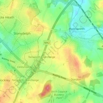
Name: Topografische Karte Birchmoor, Höhe, Relief.
Durchschnittliche Höhe: 93 m
Minimale Höhe: 59 m
Maximale Höhe: 139 m
Andere topografische Karten
Klicken Sie auf eine Karte, um ihre Topografie, ihre Höhe und ihr Relief anzuzeigen.
Pooley Country Park
United Kingdom > England > Warwickshire > North Warwickshire > Polesworth
Pooley Country Park, Shuttington CP, Polesworth, North Warwickshire, Warwickshire, West Midlands, England, United Kingdom
Durchschnittliche Höhe: 76 m