
Topografische Karte Vik
Interaktive Karte
Klicken Sie auf die Karte, um die Höhe anzuzeigen.
Über diese Karte
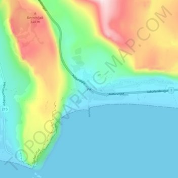
Name: Topografische Karte Vik, Höhe, Relief.
Ort: Vik, Mýrdalshreppur, Southern Region, 870, Iceland (63.39882 -19.02547 63.43882 -18.98547)
Durchschnittliche Höhe: 106 m
Minimale Höhe: -3 m
Maximale Höhe: 384 m
Vík í Mýrdal is the warmest place in Iceland, with an annual mean temperature of 5.3 °C (41.5 °F). Like most of coastal Iceland, Vík í Mýrdal has a subpolar oceanic climate (Koppen Cfc) with cold but not severe winters and cool, short summers. Its winters are among the warmest in Iceland, with an average winter day having a daytime high around 4 °C (39 °F). Because it lies on the windward side of the Gulf Stream, Vík í Mýrdal is the wettest coastal town in Iceland, with an annual rainfall of 2,250 millimetres (89 in), which is three times more than Reykjavík, five times more than Akureyri on the north coast of the island and many times more than its far northern location would normally indicate. Precipitation on the Mýrdalsjökull and Vatnajökull glaciers near the town is believed to be as high as 160 inches (4,100 mm) of rainfall equivalent, which would mean at least 160 feet (49 m) of snow at those higher altitudes.
Andere topografische Karten
Klicken Sie auf eine Karte, um ihre Topografie, ihre Höhe und ihr Relief anzuzeigen.
Reynisfjara Beach
Reynisfjara Beach, Mýrdalshreppur, Southern Region, Iceland
Durchschnittliche Höhe: 23 m
Katla
Katla, Mýrdalshreppur, Southern Region, Iceland
Durchschnittliche Höhe: 1.227 m