
Topografische Karte Oxford
Interaktive Karte
Klicken Sie auf die Karte, um die Höhe anzuzeigen.
Über diese Karte
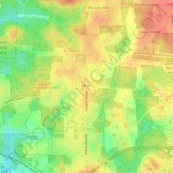
Name: Topografische Karte Oxford, Höhe, Relief.
Ort: Oxford, Newton County, Georgia, United States (33.61039 -83.88621 33.64405 -83.85842)
Durchschnittliche Höhe: 231 m
Minimale Höhe: 200 m
Maximale Höhe: 253 m
Andere topografische Karten
Klicken Sie auf eine Karte, um ihre Topografie, ihre Höhe und ihr Relief anzuzeigen.
Turner Lake
United States > Georgia > Newton County > Covington
Turner Lake, Covington, Newton County, Georgia, United States
Durchschnittliche Höhe: 217 m
High Point
United States > Georgia > Newton County
High Point, Newton County, Georgia, United States
Durchschnittliche Höhe: 211 m
Covington
United States > Georgia > Newton County
Covington, Newton County, Georgia, 30014, United States
Durchschnittliche Höhe: 219 m
Wallace Lake
United States > Georgia > Newton County > Covington
Wallace Lake, Covington, Newton County, Georgia, United States
Durchschnittliche Höhe: 227 m